Showers will be a constant threat through tomorrow, but improving conditions are on the way. Another storm is likely by the end of next week.
TODAY
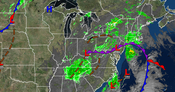
An area of low pressure and cold front will lift through the region with scattered showers throughout the day for most of the region. Periods of rain will linger over Long Island and Connecticut through this evening and will be heavy at times. Winds will veer from the southeast to the west at 5 to 15 mph. Temperatures will rise into the mid-50s to lower 60s over the interior and mid to upper 60s along the coast for highs.
TONIGHT
Scattered to broken cloud cover with isolated showers to widely scattered showers through tomorrow morning. Winds will be from the west at 5 to 15 mph. Temperatures will fall into the mid to upper 40s over the interior and lower to mid-50s along the coast for lows.
HALLOWEEN
Scattered clouds with an isolated shower are possible. Winds will be from the west at 5 to 15 mph with gusts up to 25 mph at times in the afternoon. Temperatures will rise into the lower to mid-50s over the interior and upper 50s to mid-60s along the coast for highs.
MONDAY
High pressure will produce clear skies to scattered clouds. Winds will be from the west at 5 to 15 mph. Temperatures will range from the upper 30s to lower 40s over the interior and mid-40s to lower 50s along the coast for lows and upper 50s to lower 60s over the interior and lower to mid-60s along the coast for highs.
TUESDAY THROUGH THURSDAY
A series of cold fronts will produce scattered clouds with isolated showers. Temperatures through the period will range from the lower to mid-30s over the interior and upper 30s to mid-40s along the coast for lows and mid to upper 40s over the interior and upper 40s to mid-50s along the coast for highs.
FRIDAY THROUGH SATURDAY
An area of low pressure will approach the region on Friday with periods of rain, heavy at times. The low-pressure system will pass through the coastal waters and intensify Friday night through Saturday with waves of moderate to heavy rainfall for most of the region. However, the rain will mix over to snow for locations above 1,000 feet with some minor snow accumulation possible. Temperatures on Friday will range from the lower to mid-30s over the
interior and upper 30s to lower 40s along the coast for lows and lower to mid-40s over the interior and mid to upper 40s along the coast for highs. Temperatures on Saturday will feature temperatures falling through the mid-30s over the interior and through the 40s along the coast.