Tranquil weather conditions will start this November, but a storm threat still is a lingering possibility for the end of the week.
TODAY
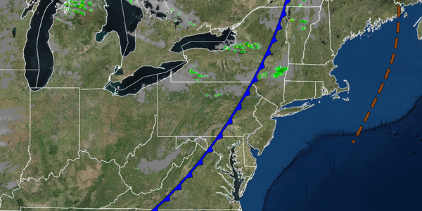
A weak cold front will exit early this morning with scattered clouds to clear skies through this evening. Winds will be from the west at 5 to 15 mph. Temperatures will rise into the upper 40s to lower 50s over the interior and mid to upper 50s along the coast for highs.
TONIGHT
Clear skies to scattered clouds are expected with winds from the west at 5 to 10 mph. Temperatures will fall into the upper 30s to lower 40s over the interior and lower to mid-40s along the coast for lows.
TOMORROW
A stronger cold front will move through the region tomorrow with scattered showers in the afternoon. Winds will be from the west at 5 to 15 mph. Temperatures will rise into the mid to upper 40s over the interior and lower to mid-50s along the coast for highs.
WEDNESDAY AND THURSDAY
A series of cold fronts and troughs will move through the region with scattered clouds and a few isolated showers. Winds will be from the west at 5 to 10 mph. Temperatures on Wednesday will range from the upper 20s to lower 30s over the interior and mid-30s to lower 40s along the coast for lows and mid to upper 40s over the interior and lower to mid-50s along the coast for highs. Temperatures on Thursday will range from the upper 20s to lower 30s
over the interior and mid-30s to lower 40s along the coast for lows and lower to mid-40s over the interior and upper 40s to lower 50s along the coast for highs.
FRIDAY AND SATURDAY
An area of low pressure will pass through the coastal waters with scattered showers through the period, possibly mixing with snow in higher elevations. Temperatures on Friday and Saturday will range from the upper 20s to mid-30s over the interior and upper 30s to mid-40s along the coast for lows and mid to upper 40s over the interior and lower to mid-50s along the coast for highs.
SUNDAY AND MONDAY
A series of weak cold fronts will move through the region with scattered clouds and isolated showers to widely scattered showers. Temperatures on Sunday will range from the upper 20s to lower 30s over the interior and mid-30s to lower 40s along the coast for lows and upper 40s to lower 50s over the interior and mid to upper 50s along the coast for highs. Temperatures on Monday will range from the lower to mid-30s over the interior and mid to upper 30s
along the coast for lows and lower to mid-50s over the interior and mid to upper 50s along the coast for highs.