Perfect weather will continue, but an end is in sight with a powerful cold front expected Friday morning. Colder conditions return by this weekend through next week.
TODAY
High pressure will be in control with clear skies to scattered cloud cover. Winds will be from the west at 5 to 10 mph through the period. Temperatures will rise into the upper 50s to lower 60s over the interior and mid to upper 60s along the coast for highs.
TONIGHT THROUGH TOMORROW
A weak cold front will pass through the region with scattered cloud cover expected. Winds will be from the west at 5 to 15 mph. Temperatures will range from the mid to upper 40s for lows and mid to upper 50s over the interior and lower to mid-60s along the coast for highs.
THURSDAY
High pressure will be in control with clear skies to scattered cloud cover. Winds will veer from the northwest to the east at 5 to 15 mph. Temperatures will range from the lower to mid-30s over the interior and upper 30s to lower 40s along the coast for lows and lower to mid-50s over the interior and upper 50s to mid-60s along the coast for highs.
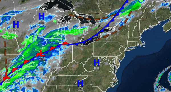
FRIDAY
A strong cold front will produce periods of rain throughout the region. The rain will be heavy at times, especially in the morning hours. Wind gusts over 30 mph will be a threat in the heaviest rainfall. Temperatures will range from the lower to mid-50s over the interior and upper 50s to lower 60s along the coast for lows and mid to upper 50s over the interior and upper 50s to lower 60s along the coast for highs.
SATURDAY AND SUNDAY
An area of low pressure will fester off the coast on Saturday and Sunday with scattered clouds and widely scattered showers along the coast and widely scattered rain and snow showers over the interior. Temperatures on Saturday will range from the lower to mid-40s for lows and lower to mid-50s over the interior and upper 50s to lower 60s along the coast for highs. Temperatures on Sunday will range from the lower to mid-30s over the interior and upper
30s to lower 40s along the coast for lows and upper 30s to lower 40s over the interior and mid to upper 40s along the coast for highs.
MONDAY AND TUESDAY
Scattered clouds are expected for most of the region, however, some flurries and snow showers are a threat for the Poconos and Catskills. Temperatures will range from the mid-20s to lower 30s over the interior and mid to upper 30s along the coast for lows and mid-30s to lower 40s over the interior and mid-40s to lower 50s along the coast for highs.