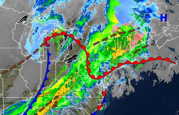
After a foggy start, a strong cold front will bring wind gusts up to 50 mph and severe thunderstorms by this evening. A mild weather pattern follows for next week.
TODAY
A cold front will approach with widely scattered showers throughout the day. The cold front will move through in the evening hours with periods of rain and strong thunderstorms. An isolated severe thunderstorm is possible with wind gusts over 60 mph, occasional lightning, heavy downpours, and isolated tornadoes. The highest threat for severe thunderstorms will be over southeastern Pennsylvania and southern New Jersey. Winds will be from the
south-southwest at 15 to 30 mph with gusts up to 50 mph. Temperatures will rise into the upper 50s to lower 60s over the interior, lower to mid-60s on the coast, and mid to upper 60s in the Delaware River Valley for highs.
TONIGHT
The cold front will exit with lingering showers followed by clearing skies towards tomorrow morning. Winds will veer to the northwest at 15 to 30 mph with gusts up to 50 mph initially, declining to 5 to 15 mph by morning. Temperatures will fall into the lower to mid-30s over the interior and upper 30s to lower 40s along the coast for lows.
TOMORROW
High pressure will build into the region with scattered cloud cover. Winds will be from the northwest at 5 to 15 mph. Temperatures will rise into the upper 30s to lower 40s over the interior, lower to mid-40s along the coast, and mid to upper 40s in the Delaware River Valley for highs.
MONDAY
High pressure will produce clear skies to scattered cloud cover. Winds will be from the southwest at 5 to 15 mph. Temperatures will range from the upper 20s to lower 30s over the interior and lower to mid-30s along the coast for lows and lower to mid-40s over the interior and upper 40s to lower 50s along the coast for highs.
TUESDAY AND WEDNESDAY
High pressure will produce clear skies to scattered cloud cover. Temperatures on Tuesday will range from the upper 20s to lower 30s over the interior and lower to mid-30s along the coast for lows and mid to upper 40s over the interior and lower to mid-50s along the coast for highs. Temperatures on Wednesday will range from the upper 20s to lower 30s for lows and upper 40s to lower 50s over the interior and lower to mid-50s along the coast for
highs.
THURSDAY
High pressure will exit the region with increasing clouds throughout the day. Temperatures will range from the lower to mid-40s over the interior and mid to upper 40s along the coast for lows and lower to mid-50s over the interior and mid to upper 50s along the coast for highs.
FRIDAY
A cold front will move through the region with a few isolated showers. Temperatures will range from the mid-30s to lower 40s over the interior and mid-40s to lower 50s along the coast for lows and mid-40s to lower 50s over the interior and lower to mid-50s along the coast for highs.
SATURDAY
Another cold front will produce scattered showers throughout the region. Temperatures will range from the mid to upper 40s for lows and mid to upper 50s over the interior and upper 50s to lower 60s along the coast for highs.