Mild weather will continue with a few pesky showers. Another low-pressure system will bring rain, ice, and snow to the region this weekend.
TODAY
A warm front will continue to lift to the north of the region with areas of fog, drizzle, scattered to broken clouds, and isolated showers. Winds will be from the southwest at 5 to 15 mph. Temperatures will rise into the mid to upper 50s over the interior and upper 50s to mid-60s along the coast for highs.
TONIGHT THROUGH TOMORROW
A cold front will approach the region with scattered to broken cloud cover and isolated showers through the morning. Scattered clouds are expected in the afternoon. Winds will be from the west at 5 to 15 mph. Temperatures will range from the upper 30s to mid-40s over the interior and upper 40s to lower 50s along the coast for lows and upper 40s to lower 50s over the interior and mid-50s along the coast for highs.
SATURDAY
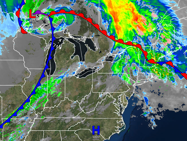
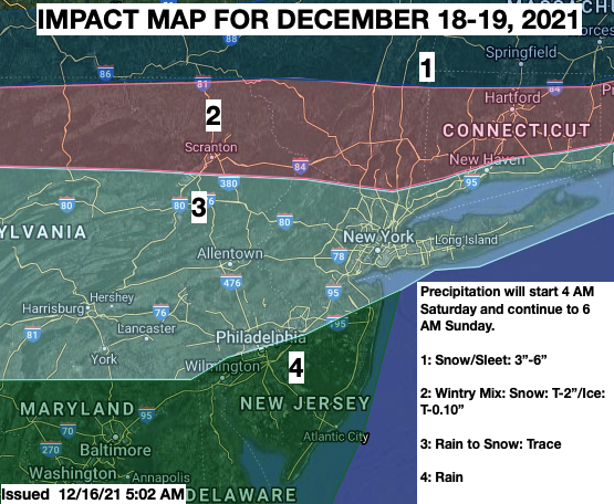
An area of low pressure will approach the region with periods of rain developing throughout the region, mixing over to snow, sleet, and freezing rain for the northern interior. Details on snow and ice impacts can be found below. Winds will be from the east-northeast at 5 to 15 mph. Temperatures will range from the lower to mid-30s over the interior and upper 30s to mid-40s along the coast for lows and mid-30s to lower 40s over the interior and
mid-40s to lower 50s along the coast for highs.
SUNDAY
The low-pressure system will exit with periods of snow and sleet over the interior and rain mixing over to snow along the coast in the early morning hours. Skies will clear towards the afternoon. Temperatures will range from the upper 20s to lower 30s over the interior and lower to mid-30s along the coast for lows and upper 20s to lower 30s over the interior and mid to upper 30s along the coast for highs.