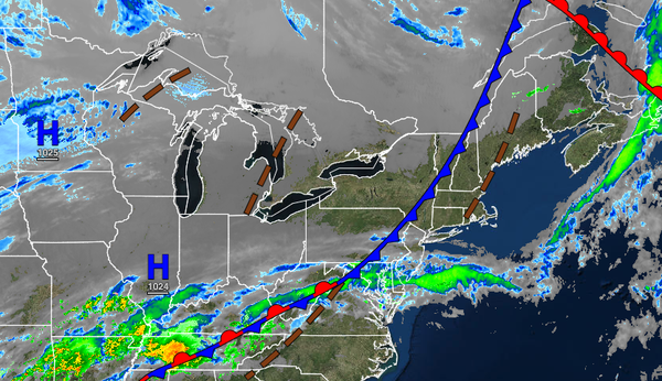
After a cold front allows some cold air to bleed into the region, the stage will be set for an icy wintry mix for interior sections tomorrow morning.
TODAY
A cold front will move through the region with scattered to broken cloud cover and isolated showers through the morning. Scattered clouds are expected in the afternoon. Winds will veer from the southwest to the west at 5 to 15 mph. Temperatures will rise into the upper 40s to lower 50s over the interior and mid-50s along the coast for highs.
TONIGHT
Clouds will increase with a wintry mix of snow, sleet, and freezing rain developing over the interior and periods of rain along the coast towards morning. Winds will veer to the north at 5 to 15 mph. Temperatures will fall into the lower to mid-30s over the interior and upper 30s to lower 40s along the coast for lows.
TOMORROW
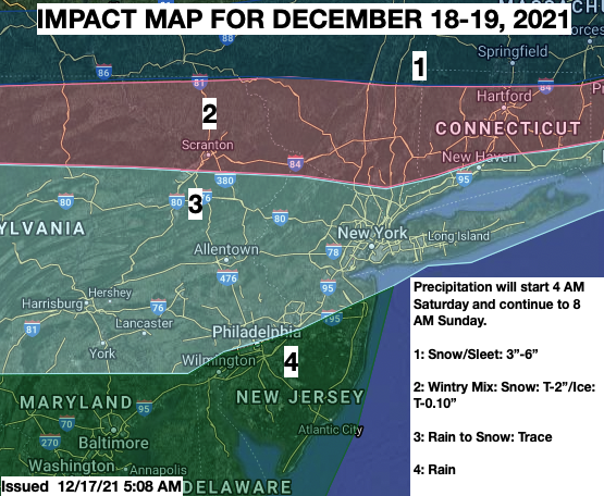
An area of low pressure will produce a wintry mix of snow, sleet, and freezing rain over the northern interior that will mix over to rain with some snow and sleet accumulations. Periods of rain are expected along the coast. Details on snow and ice impacts can be found below. Winds will veer to the east-northeast at 5 to 15 mph. Temperatures will rise into the mid-30s to lower 40s over the interior and mid-40s to lower 50s along the coast
for highs.
SUNDAY
The low-pressure system will exit with scattered snow showers over the interior and rain and snow showers along the coast early in the morning. Skies will clear by the late morning hours through the evening. Winds will be from the northwest at 10 to 20 mph with gusts over 25 mph at times. Temperatures will range from the upper 20s to lower 30s over the interior and lower to mid-30s along the coast for lows and upper 20s to lower 30s over the
interior and mid-30s to lower 40s along the coast for highs.