An area of low pressure will bring periods of rain after a period of an icy wintry mix early this morning for interior locations. A chillier and dry weather pattern is expected leading up to Christmas.
TODAY
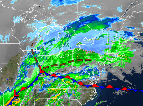
An area of low pressure will produce a wintry mix of snow, sleet, and freezing rain over the northern interior this morning that will mix over to rain with some minor snow and sleet accumulations. Periods of rain are expected elsewhere. Winds will veer to the east-northeast at 5 to 15 mph. Temperatures will rise into the mid-30s to lower 40s over the interior and mid-40s to lower 50s along the coast for highs.
TOMORROW
The low-pressure system will exit with scattered snow showers over the interior and rain and snow showers along the coast early in the morning. Skies will clear by the late morning hours through the evening. Winds will be from the northwest at 10 to 20 mph with gusts over 25 mph at times. Temperatures will range from the upper 20s to lower 30s over the interior and lower to mid-30s along the coast for lows and upper 20s to lower 30s over the
interior and mid-30s to lower 40s along the coast for highs.
MONDAY
High pressure will produce clear skies to scattered clouds along with light and variable winds. Temperatures on Monday will range from the upper 10s to mid-20s for lows and lower to mid-30s for highs.
TUESDAY
A weak cold front will move through the region with scattered cloud cover expected. Temperatures on Tuesday will range from the mid-20s to lower 30s for lows and lower to mid-40s over the interior and mid to upper 40s along the coast for highs.
WEDNESDAY
An area of low pressure off the coast will produce a few isolated rain and snow showers with otherwise scattered cloud cover. Temperatures will range from the lower to mid-20s over the interior and upper 20s to lower 30s along the coast for lows and upper 30s to mid-40s for highs.
THURSDAY AND FRIDAY
High pressure will produce clear skies to scattered cloud cover. Temperatures on Thursday will range from the lower to mid-20s over the interior and mid to upper 20s along the coast for lows and mid to upper 30s over the interior and upper 30s to lower 40s along the coast for highs. Temperatures on Friday will range from the upper 20s to mid-30s over the interior and upper 30s to lower 40s along the coast for lows and upper 30s to mid-40s over the
interior and upper 40s to mid-50s along the coast for highs.
CHRISTMAS DAY/SATURDAY
An area of low pressure will move through the region with periods of showers. Temperatures will range from the mid to upper 30s for lows and lower to mid-50s for highs.