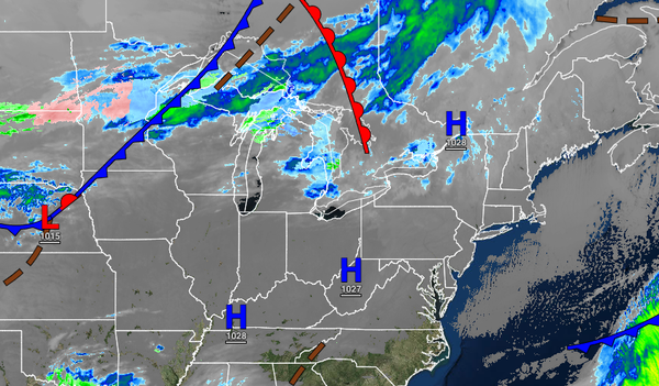
The weather pattern leading up to Christmas is not expected to feature any major storms, but some pesky showers will be a concern leading up to Saturday, Christmas Day.
TODAY
High pressure will produce clear skies to scattered cloud cover with light and variable winds. Temperatures will rise into the mid to upper 30s for highs throughout the region.
TONIGHT
High pressure will exit the region with scattered cloud cover. Winds will be from the southwest at 5 to 15 mph. Temperatures will fall into the lower to mid-20s over the interior and upper 20s to lower 30s along the coast for lows.
TOMORROW
A weak cold front will follow with scattered cloud cover. Winds will veer to the northwest at 5 to 15 mph. Temperatures will rise into the upper 30s to lower 40s for highs.
WEDNESDAY
An area of low pressure will pass well southeast of the region with scattered clouds and a few flurries and isolated showers in the afternoon. Winds will back from the northeast to the northwest at 5 to 15 mph. Temperatures will range from the mid-20s to lower 30s over the interior and mid-30s to lower 40s along the coast for lows and upper 30s to lower 40s over the interior and lower to mid-40s along the coast for highs.
THURSDAY
High pressure will produce tranquil weather conditions. Temperatures will range from the lower to mid-20s over the interior and mid to upper 20s along the coast for lows and lower to mid-30s over the interior and upper 30s to lower 40s along the coast for highs.
FRIDAY (CHRISTMAS EVE)
A warm front will approach the region with increasing clouds and scattered showers by the evening. Temperatures will range from the upper 20s to lower 30s over the interior and lower to mid-30s along the coast for lows and mid to upper 40s over the interior and upper 40s to lower 50s along the coast for highs.
SATURDAY (CHRISTMAS)
A cold front will follow in the morning with a few scattered showers followed by clearing skies in the afternoon. Temperatures will range from the upper 30s to mid-40s over the interior and mid to upper 40s along the coast for lows and lower to mid-40s over the interior and upper 40s to lower 50s along the coast for highs.
SUNDAY AND MONDAY
High pressure will produce clear skies to scattered clouds. Temperatures on Sunday will range from the mid-20s to lower 30s for lows and mid to upper 30s over the interior and lower to mid-40s along the coast for highs. Temperatures on Monday will range from the mid to upper 20s for lows and lower to mid-40s over the interior and mid to upper 40s along the coast for highs.