...WINTER WEATHER ADVISORY IN EFFECT FROM 10 PM THIS EVENING TO
9 AM EST SATURDAY...

* WHAT...Mixed precipitation including light freezing rain
  expected. Total snow accumulations of up to one inch and ice
  accumulations of a light glaze.

* WHERE...In Pennsylvania, Northern Wayne, Pike and Southern
  Wayne counties. In New York, Madison, Chenango, Otsego,
  Delaware and Sullivan counties.

* WHEN...From 10 PM this evening to 9 AM EST Saturday.

* IMPACTS...Plan on slippery road conditions, especially on
  untreated back roads.
...WINTER WEATHER ADVISORY IN EFFECT FROM 10 PM THIS EVENING TO
10 AM EST SATURDAY...

* WHAT...Freezing rain expected. Total ice accumulations of a
  light glaze to around one tenth of an inch.

* WHERE...Litchfield County in northwestern Connecticut and the
  Schoharie Valley, eastern Catskills, Helderbergs, mid Hudson
  Valley, Taconics, eastern Albany and western Rensselaer
  Counties in eastern New York.

* WHEN...From 10 PM this evening to 10 AM EST Saturday.

* IMPACTS...Difficult travel conditions are possible due to
  slippery roads.
...WINTER WEATHER ADVISORY IN EFFECT FROM 10 PM THIS EVENING TO
9 AM EST SATURDAY...
* WHAT...Freezing rain expected. Total ice accumulations of a
light glaze.
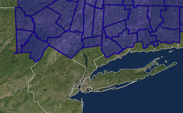
* WHERE...Portions of southern Connecticut and southeast New
York.
* WHEN...From 10 PM this evening to 9 AM EST Saturday.
* IMPACTS...Very slippery sidewalks, roads and bridges are
possible.
...WINTER WEATHER ADVISORY IN EFFECT FROM 1 AM TO 10 AM EST
SATURDAY...

* WHAT...Freezing rain expected. Total ice accumulations of a
  light glaze to less than one tenth of an inch.

* WHERE...Portions of northern Connecticut, eastern and
  southeastern Massachusetts and central and northern Rhode
  Island.

* WHEN...From 1 AM to 10 AM EST Saturday.

* IMPACTS...Slippery travel conditions are possible late tonight
  into Christmas morning, especially on untreated surfaces.