After some flurries and light snow early this morning, another round of wintry mix is on the way for tonight's trip for Santa Claus. An active pattern continues through the last week of 2021.
TODAY
A warm front will approach the region with increasing clouds through this evening. Winds will be from the west at 5 to 15 mph. Temperatures will rise into the lower to mid-40s over the interior and mid-40s to lower 50s along the coast for highs.
TONIGHT
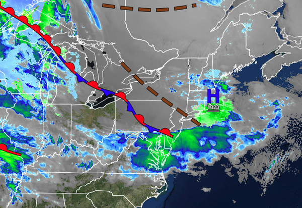
As the warm front lifts through the region a wintry mix of sleet and freezing rain will be a threat for northeastern Pennsylvania, northwestern New Jersey, the Catskills, Hudson River Valley, and interior Connecticut while rain is expected elsewhere. The wintry mix will produce slick roadways and surfaces with a trace to 0.10" of ice. Winds will back to the southwest at 5 to 15 mph. Temperatures will fall into the lower to mid-30s over the
interior and upper 30s to lower 40s along the coast for lows.
TOMORROW (CHRISTMAS)
An area of low pressure will follow with the wintry mix change over to rain over the interior by late morning and periods of rain continuing along the coast, ending by the evening hours. Winds will veer from the west to the northwest at 5 to 15 mph. Temperatures will rise into the mid to upper 40s over the interior and upper 40s to lower 50s along the coast for highs.
SUNDAY
Scattered clouds with windy conditions are expected. Winds will be from the northwest at 10 to 20 mph with gusts over 30 mph at times. Temperatures will range from the lower to mid-30s over the interior and upper 30s to lower 40s along the coast for lows and upper 30s to lower 40s over the interior and lower to mid-40s along the coast for highs.
MONDAY
An area of low pressure will produce a wintry mix of snow, sleet, and freezing rain for higher elevations with some snow and ice accumulation possible. Periods of rain are expected along the coast. Temperatures will range from the mid to upper 20s over the interior and lower to mid-30s along the coast for lows and mid to upper 30s over the interior and lower to mid-40s along the coast for highs.
TUESDAY
Another area of low pressure will produce periods of rain. Temperatures will range from the lower to mid-30s for lows and upper 30s to lower 40s over the interior and lower to mid-40s along the coast for highs.
WEDNESDAY
A weak trough will support the development of scattered rain and snow showers over the region. Temperatures will range from the mid to upper 20s over the interior and lower to mid-30s along the coast for lows and mid to upper 30s for highs.
THURSDAY
Another low-pressure system will produce periods of snow, sleet, and rain. Temperatures will range from the lower to mid-30s over the interior and mid to upper 30s along the coast for lows and lower to mid-40s over the interior and mid to upper 40s along the coast.
FRIDAY
High pressure will produce scattered cloud cover. Temperatures will range from the upper 10s to the lower 20s over the interior and mid-20s to lower 30s along the coast for lows and lower to mid-30s over the interior and mid-30s to lower 40s along the coast for highs.