Pesky showers will linger today but clear in time for New Year's Eve. A stormy start to the new year is expected with rain and snow a growing threat.
TODAY
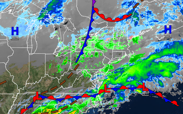
An area of low pressure will produce scattered showers and cloudy skies. Winds will back from the northeast to the northwest at 5 to 15 mph. Temperatures will rise into the mid to upper 40s over the interior and lower to mid-50s along the coast for highs.
TONIGHT
Scattered clouds and a few isolated showers in the evening will give way to clearing skies towards tomorrow morning. Winds will be from the northwest at 5 to 10 mph. Temperatures will fall into the mid to upper 30s over the interior and lower to mid-40s along the coast for lows.
TOMORROW (NEW YEAR'S EVE)
High pressure will produce scattered cloud cover. Winds will be from the northwest at 5 to 15 mph. Temperatures will rise into the upper 40s to lower 50s over the interior and mid to upper 50s along the coast for highs.
SATURDAY (NEW YEAR'S DAY)
A cold front will slowly approach with widely scattered showers in the morning becoming widespread by the afternoon. Winds will be from the south at 10 to 20 mph with gusts over 30 mph at times. Temperatures will range from the lower to mid-40s over the interior and upper 40s to lower 50s along the coast for lows and mid to upper 50s over the interior and New York City metropolitan area and upper 50s to lower 60s in the Philadelphia metropolitan area
for highs.
SUNDAY
An area of low pressure will produce periods of rain throughout the region. The rain will gradually mix over to sleet and snow before ending in the evening hours from northwest to southeast. Some snow and ice accumulation is possible for higher elevations. Temperatures will range from the upper 40s to lower 50s over the interior and mid to upper 50s along the coast for morning lows and mid to upper 50s over the interior and lower to mid-60s along
the coast for highs. Temperatures will fall through the 40s, 30s, and 20s in the afternoon and evening hours.
MONDAY
The low-pressure system will exit with lingering snow showers and flurries in the early morning hours followed by clearing skies and windy conditions. Temperatures will range from the upper 10s to the lower 20s over the interior and mid to upper 20s along the coast for lows and mid to upper 20s over the interior and lower to mid-30s along the coast for highs.
TUESDAY
High pressure will produce scattered clouds. Temperatures will range from the lower to mid-20s for lows and upper 30s to lower 40s for highs.
WEDNESDAY
High pressure will exit the region with increasing cloud cover. Temperatures will range from the upper 20s to mid-30s over the interior and mid-30s to lower 40s along the coast for lows and mid to upper 40s over the interior and upper 40s to lower 50s along the coast for highs.
THURSDAY
A cold front will move through the region with scattered showers. An area of low pressure will approach from the Tennessee River Valley in the evening and begin redeveloping off the Mid Atlantic coast with widespread rain, sleet, and snow mixing over to snow towards midnight. Snow and ice accumulation will be possible. Temperatures will range from the mid to upper 20s over the interior and upper 20s to mid-30s along the coast for lows and upper
20s to lower 30s over the interior and mid-30s to lower 40s along the coast for highs. Temperatures will fall rapidly through the 30s and 20s in the evening.