...WINTER STORM WATCH IN EFFECT FROM FRIDAY EVENING THROUGH
SATURDAY EVENING...
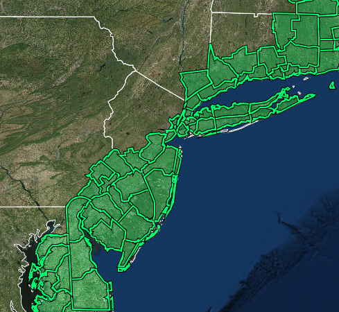
* WHAT...Heavy snow possible. Total snow accumulations of 6 to 12
inches possible. Winds could gust as high as 45 mph.
* WHERE...Portions of northeast New Jersey, southern Connecticut
and southeast New York.
* WHEN...From Friday evening through Saturday evening.
* IMPACTS...Travel could be very difficult. Gusty winds could
bring down tree branches.
* ADDITIONAL DETAILS...There continues to be greater than usual
forecast uncertainty with the track of this storm, and the axis
of heaviest snowfall may shift in subsequent forecast updates.
...WINTER STORM WATCH REMAINS IN EFFECT FROM LATE FRIDAY NIGHT
THROUGH SATURDAY EVENING...

* WHAT...Heavy snow possible. Total snow accumulations of 8 to 17
  inches possible. Winds could gust as high as 60 mph, especially
  on Cape Cod.

* WHERE...Portions of northern Connecticut and central, eastern
  and northeastern Massachusetts.

* WHEN...From late Friday night through Saturday evening.

* IMPACTS...Travel could be very difficult to impossible. Strong
  winds could cause tree damage.
...WINTER STORM WATCH IN EFFECT FROM LATE FRIDAY NIGHT THROUGH
SATURDAY EVENING...

* WHAT...Heavy snow possible. Total snow accumulations of 8 to 17
  inches possible. Winds could gust as high as 60 mph, especially
  on Cape Cod.

* WHERE...Portions of northern Connecticut and central, eastern
  and northeastern Massachusetts.

* WHEN...From late Friday night through Saturday evening.

* IMPACTS...Travel could be very difficult to impossible. Strong
  winds could cause tree damage.
...WINTER STORM WATCH IN EFFECT FROM FRIDAY EVENING THROUGH
SATURDAY EVENING...

* WHAT...Heavy snow possible. Total snow accumulations of 6 to 12
  inches possible. Winds could gust as high as 45 mph.

* WHERE...The coastal counties of New Jersey and Sussex County in
  Delaware.

* WHEN...From Friday evening through Saturday evening.

* IMPACTS...Travel could be very difficult to impossible.

* ADDITIONAL DETAILS...Snow is expected to begin Friday evening in
  Delmarva and southern New Jersey, spreading northward overnight
  into Saturday morning. Snow may be heavy at times through mid
  afternoon before diminishing Saturday evening. Strong winds may
  generate blowing snow and very low visibilities at times. The
  storm total snow forecast remains very uncertain, so stay tuned
  to the latest forecasts.
...WINTER STORM WATCH IN EFFECT FROM FRIDAY EVENING THROUGH
SATURDAY EVENING...

* WHAT...Heavy snow possible. Total snow accumulations of 4 to 9
  inches possible. Winds could gust as high as 40 mph.

* WHERE...The eastern shore of Maryland, northern and central
  Delaware, far southeastern Pennsylvania, and much of central and
  southern New Jersey.

* WHEN...From Friday evening through Saturday evening.

* IMPACTS...Travel could be very difficult.

* ADDITIONAL DETAILS...Snow is expected to begin Friday evening in
  Delmarva and southern New Jersey, spreading northward overnight
  into Saturday morning. Snow may be heavy at times through early
  afternoon before diminishing late in the day. Winds may generate
  areas of blowing snow and low visibilities at times. The storm
  total snow forecast remains very uncertain, so stay tuned to the
  latest forecasts.
|
|