A powerful cold front will bring an end to the mild weather pattern by tomorrow morning. The threat for frozen precipitation begins to return for higher elevations.
TODAY
High pressure will be in control with clear skies to scattered cloud cover. Winds will veer from the north to the east at 5 to 15 mph. Temperatures will rise into the lower to mid-50s over the interior and upper 50s to lower 60s along the coast for highs.
TONIGHT
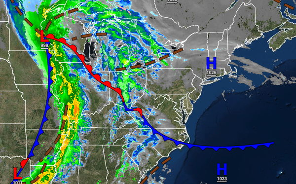
A strong cold front will approach tonight with increasing clouds and showers developing towards midnight. Winds will veer to the southeast at 10 to 20 mph. Temperatures will fall into the lower to mid-50s over the interior and mid to upper 50s along the coast for lows.
TOMORROW
The strong cold front will produce periods of rain throughout the region from 4 AM to 2 PM. The rain will be heavy at times, especially in the morning hours. Winds will veer from the southeast to the west at 10 to 20 mph with gusts over 30 mph at times. Temperatures will rise into the mid to upper 50s over the interior and upper 50s to lower 60s along the coast for highs.
SATURDAY
A strong cold front will move through the region on Saturday with widely scattered showers to scattered showers. Winds will be from the southwest at 5 to 15 mph. Temperatures will range from the lower to mid-40s for lows and upper 40s to lower 50s over the interior and mid-50s to lower 60s along the coast for highs.
SUNDAY
A weak trough will pass through the region with isolated showers on the coast and isolated rain and snow showers over the interior. Temperatures will range from the upper 20s to mid-30s over the interior and upper 30s to lower 40s along the coast for lows and lower to mid-40s over the interior and upper 40s to lower 50s along the coast for highs.
MONDAY
An area of low pressure will develop over the coastal waters with scattered showers along the coast and a mix of snow, sleet, and rain showers for the higher elevations above 1,000 feet. No snow or ice accumulation is expected at this time. Temperatures will range from the lower to mid-30s over the interior and upper 30s to mid-40s along the coast for lows and mid to upper 40s over the interior and lower to mid-50s along the coast for highs.
TUESDAY
A cold front will follow with isolated rain and snow showers. Temperatures will range from the upper 20s to mid-30s over the interior and mid to upper 30s along the coast for lows and upper 30s to lower 40s over the interior and mid to upper 40s along the coast for highs.
WEDNESDAY
High pressure will be in control with clear skies to scattered clouds. Temperatures will range from the upper 20s to lower 30s over the interior and lower to mid-30s along the coast for lows and upper 30s to lower 40s over the interior and mid to upper 40s along the coast for highs.
THURSDAY
A cold front will move through the region with scattered showers expected. Temperatures will range from the mid to upper 40s over the interior and upper 40s to lower 50s along the coast for lows and mid to upper 50s over the interior and upper 50s to lower 60s along the coast for highs.