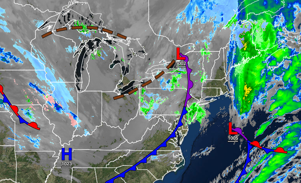
An intensifying low-pressure system off the New England coast will support the threat of rain and snow showers and windy conditions today. A strong cold front follows on Friday.
TODAY
A cold front will pass through the region while another low-pressure system lifts towards the Gulf of Maine which will produce scattered rain and snow showers throughout the region. No accumulation is expected throughout the day. Winds will veer to the west at 10 to 20 mph with gusts up to 35 mph. Temperatures will rise into the lower to mid-40s over the interior and mid to upper 40s along the coast for highs.
TONIGHT
A series of troughs will pass through the region with a few flurries possible down along the coast. Some lake-enhanced snow showers will be a threat for the Poconos and Catskills with some minor snow accumulation up to 2" for elevations above 700 feet. Winds will be from the west at 5 to 15 mph. Temperatures will fall into the upper 20s to lower 30s over the interior, lower to mid-30s in the suburbs, and mid to upper 30s along the immediate coast
for lows.
TOMORROW
Another trough will pass through the region with a few lingering flurries and showers in the morning followed by scattered clouds in the afternoon. Winds will be from the west at 5 to 15 mph. Temperatures will rise into the lower to mid-40s over the interior and mid to upper 40s along the coast for highs.
WEDNESDAY
High pressure will produce clear skies to scattered clouds. Winds will be from the southwest at 5 to 15 mph. Temperatures will range from the upper 20s to lower 30s over the interior and lower to mid-30s along the coast for lows and upper 40s to mid-50s over the interior and upper 50s to mid-60s along the coast for highs.
THURSDAY
A cold front will approach the region with increasing clouds and showers developing in the afternoon and evening hours. Temperatures will range from the mid-40s to lower 50s for lows and mid-50s to lower 60s on the immediate coast and lower to mid-60s elsewhere for highs.
FRIDAY
A powerful cold front with a wave of low pressure will produce periods of rain, possibly mixing with some snow and sleet for the higher elevations. Temperatures will range from the lower to mid-30s over the interior and upper 30s to lower 40s along the coast for lows and upper 30s to lower 40s over the interior and mid to upper 40s along the coast for highs.
SATURDAY AND SUNDAY
High pressure will be in control with clear skies to scattered cloud cover. Temperatures on Saturday will range from the mid to upper 20s over the interior and lower to mid-30s along the coast for lows and lower to mid-40s for highs. Temperatures on Sunday will range from the mid to upper 30s for lows and lower to mid-40s over the interior and upper 40s to lower 50s along the coast for highs.
MONDAY
A cold front will produce scattered showers. Temperatures will range from the mid to upper 30s over the interior and lower to mid-40s along the coast for lows and mid to upper 40s over the interior and lower to mid-50s along the coast for highs.