Tranquil conditions are expected for Thanksgiving, but a chilly and unsettled pattern follows for the following weekend.
TODAY
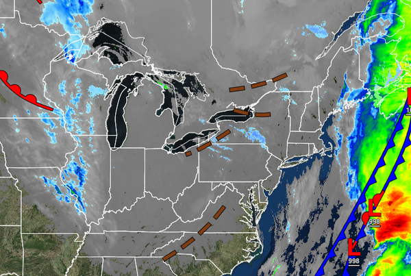
A series of troughs will pass through the region with scattered clouds and a few flurries. Snow showers will be a threat for the Poconos and Catskills with snow accumulation of a dusting to an inch possible for elevations above 1,000 feet. Winds will be from the northwest at 5 to 15 mph. Temperatures will rise into the mid to upper 30s over the interior and lower to mid-40s along the coast for highs.
TONIGHT THROUGH TOMORROW
High pressure will build into the region with clear skies to scattered cloud cover. Winds will be from the northwest at 5 to 15 mph. Temperatures will range from the mid to upper 20s over the interior and upper 20s to lower 30s along the coast for lows and lower to mid-40s for highs.
THANKSGIVING
High pressure will exit the region with increasing clouds throughout the day. Winds will be from the west at 5 to 15 mph. Temperatures will range from the upper 20s to mid-30s for lows and mid to upper 40s over the interior and lower to mid-50s along the coast for highs.
FRIDAY
A strong cold front will follow with periods of rain, mixing with sleet and snow at times for the higher elevations in the morning hours. Scattered clouds with lingering flurries and snow showers are expected in the afternoon. Windy conditions are expected. Temperatures will range from the mid to upper 30s over the interior and lower to mid-40s along the coast for lows and upper 30s to lower 40s over the interior and mid to upper 40s along the
coast for highs.
SATURDAY THROUGH MONDAY
A series of troughs and cold fronts will pass through the region with scattered clouds and flurries. Some steadier snow showers will be a threat for the Poconos and Catskills with minor snow accumulation. Temperatures on Saturday will range from the upper 20s to mid-30s for lows and lower to mid-30s over the interior and upper 30s to lower 40s along the coast for highs. Temperatures on Sunday will range from the lower to mid-20s over the interior
and upper 20s to lower 30s along the coast for lows and mid to upper 30s over the interior and upper 30s to lower 40s along the coast for highs. Temperatures on Monday will range from the lower to mid-20s over the interior and upper 20s along the coast for lows and upper 20s to lower 30s over the interior and mid to upper 30s along the coast for highs.
TUESDAY
An area of low pressure and cold front will approach with scattered showers along the coast and a mix of rain and snow showers changing over to snow showers over the interior. Temperatures will range from the lower to mid-20s over the interior, upper 20s to mid-30s in the suburbs, and mid to upper 30s along the coast for lows and lower to mid-30s over the interior, upper 30s to lower 40s in the suburbs, and mid to upper 40s along the coast for
highs.