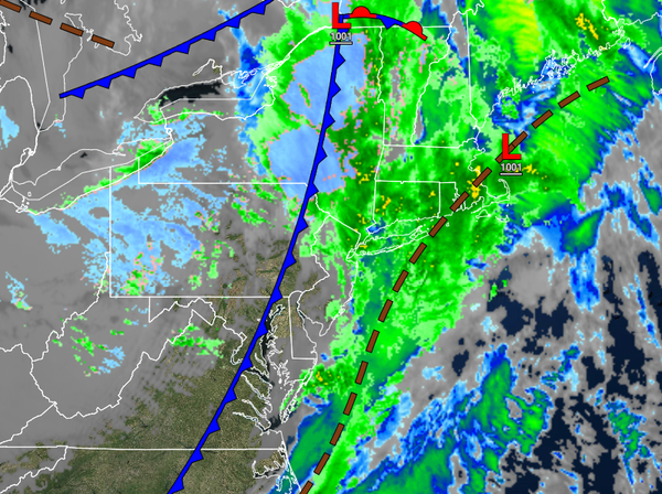
After mild and pleasant weather conditions for Thanksgiving, a cold front is slicing through the region this morning with a return of some winter chill. Another low-pressure system brings the threat of snowfall this weekend for higher elevations.
TODAY
A cold front will clear the region this morning with periods of showers giving way to scattered clouds and a few flurries. Winds will veer to the northwest at 10 to 20 mph with gusts up to 35 mph at times. Temperatures will rise into the upper 30s to lower 40s over the interior and lower to mid-40s along the coast for highs ahead of the cold front passage and then fall through the 30s and 20s this evening.
TONIGHT THROUGH TOMORROW
A series of weak troughs will pass through the region with scattered clouds and an occasional flurry. Winds will be from the northwest at 10 to 20 mph with gusts up to 30 mph. Temperatures will range from the mid to upper 20s over the interior and lower to mid-30s along the coast for lows and lower to mid-30s over the interior and upper 30s to lower 40s along the coast for highs.
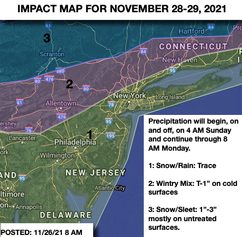
SUNDAY
An area of low pressure will pass through the region with rain and snow showers throughout the day. The wintry mix will gradually change over to snow showers in the evening with minor snowfall accumulation. Snowfall accumulation can be found on the impact map below. Winds will be from the west at 5 to 15 mph. Temperatures will range from the mid to upper 20s over the interior and lower to mid-30s along the coast for lows and lower to
mid-30s over the interior, mid to upper 30s in the New York City metropolitan area, and lower to mid-40s in the Philadelphia metropolitan area for highs.