A few snow showers will make for some slick conditions today with a dusting of snow possible for many locations. A major warm-up of the weather pattern will follow.
TODAY
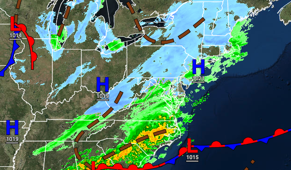
An area of low pressure passing through the coastal waters will produce periods of rain and snow showers that will gradually mix over to snow showers this evening. Most locations can expect a trace to a dusting of snowfall at most, however, a few locations north and west of the major cities may have accumulations up to 2" on cold surfaces. Winds will be from the north at 5 to 10 mph. Temperatures will rise into the lower to mid-30s over the
interior and upper 30s to lower 40s along the coast for highs.
TONIGHT
The low-pressure system will exit with lingering snow showers this evening followed by clearing skies. Winds will be from the northwest at 5 to 10 mph. Temperatures will fall into the lower to mid-20s over the interior and upper 20s to lower 30s along the coast for lows.
TOMORROW
High pressure will produce clear skies and tranquil weather conditions. Winds will be light and variable. Temperatures will range from the lower to mid-20s over the interior and upper 20s to lower 30s along the coast for lows and mid to upper 30s over the interior and upper 30s to lower 40s along the coast for highs.
FRIDAY
A warm front will lift through the region with increasing clouds through the day and scattered showers expected in the evening. Winds will be from the south at 5 to 15 mph. Temperatures will range from the lower to mid-30s for lows and lower to mid-40s over the interior and upper 40s to lower 50s along the coast for highs.
SATURDAY
A cold front will slowly move through the region with periods of rain, heavy at times. A few embedded thunderstorms will be possible with intense downpours, occasional lightning, and wind gusts over 40 mph. Temperatures will range from the lower to mid-40s over the interior and upper 40s to lower 50s along the coast for lows and mid to upper 50s over the interior and upper 50s to mid-60s along the coast for highs.
SUNDAY
The cold front will clear the region in the morning with a few lingering rain and snow showers followed by clearing skies. Temperatures will range from the lower to mid-30s over the interior and upper 30s to lower 40s along the coast for lows and upper 30s over the interior and lower to mid-40s along the coast for highs.
MONDAY THROUGH WEDNESDAY
High pressure will produce clear skies to scattered cloud cover. Temperatures on Monday will range from the upper 20s to lower 30s over the interior and lower to mid-30s along the coast for lows and lower to mid-40s over the interior and upper 40s to lower 50s along the coast for highs. Temperatures on Tuesday will range from the upper 20s to lower 30s over the interior and lower to mid-30s along the coast for lows and mid to upper 40s over the
interior and lower to mid-50s along the coast for highs. Temperatures on Wednesday will range from the upper 20s to lower 30s for lows and upper 40s to lower 50s over the interior and lower to mid-50s along the coast for highs.