A steady warm-up will continue through today with Spring-like conditions by tomorrow morning along with strong wind gusts and the threat for severe thunderstorms by tomorrow evening.
TODAY
A warm front will lift through the region with increasing clouds through the day and scattered showers expected in the evening. Winds will be from the south at 5 to 15 mph. Temperatures will rise into the lower to mid-40s over the interior and upper 40s to lower 50s along the coast for highs.
TONIGHT
Clouds will continue to increase with isolated showers to widely scattered showers developing towards tomorrow morning. Winds will be from the south at 5 to 15 mph with gusts up to 20 mph. Temperatures will fall into the lower to mid-40s for lows.
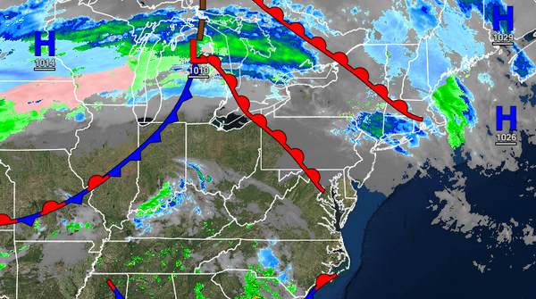
TOMORROW
A cold front will approach with widely scattered showers throughout the day. The cold front will move through in the evening hours with periods of rain and strong thunderstorms. An isolated severe thunderstorm is possible with wind gusts over 60 mph, occasional lightning, and heavy downpours. Winds will be from the south at 10 to 25 mph with gusts up to 50 mph. Temperatures will range from the lower to mid-40s over the interior and upper
40s to lower 50s along the coast for lows and upper 50s to lower 60s over the interior, lower to mid-60s on the coast, and mid to upper 60s in the Delaware River Valley for highs.
SUNDAY
The cold front will clear the region in the morning with a few lingering rain and snow showers early in the morning followed by clearing skies. Winds will be from the northwest at 5 to 15 mph. Temperatures will range from the lower to mid-30s over the interior and upper 30s to lower 40s along the coast for lows and upper 30s to lower 40s over the interior, lower to mid-40s along the coast, and mid to upper 40s in the Delaware River Valley for
highs.
MONDAY THROUGH WEDNESDAY
High pressure will produce clear skies to scattered cloud cover. Temperatures on Monday will range from the upper 20s to lower 30s over the interior and lower to mid-30s along the coast for lows and lower to mid-40s over the interior and upper 40s to lower 50s along the coast for highs. Temperatures on Tuesday will range from the upper 20s to lower 30s over the interior and lower to mid-30s along the coast for lows and mid to upper 40s over the
interior and lower to mid-50s along the coast for highs. Temperatures on Wednesday will range from the upper 20s to lower 30s for lows and upper 40s to lower 50s over the interior and lower to mid-50s along the coast for highs.
THURSDAY
High pressure will exit the region with increasing clouds throughout the day. Temperatures will range from the lower to mid-40s over the interior and mid to upper 40s along the coast for lows and lower to mid-50s over the interior and mid to upper 50s along the coast for highs.
FRIDAY
A cold front will move through the region with a few isolated showers. Temperatures will range from the mid-30s to lower 40s over the interior and mid-40s to lower 50s along the coast for lows and mid-40s to lower 50s over the interior and lower to mid-50s along the coast for highs.