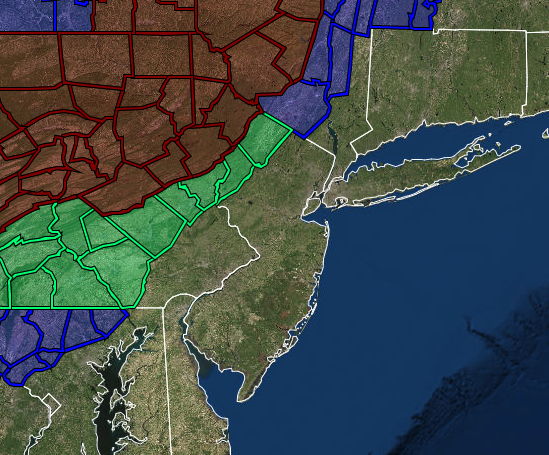
Winter Storm Warnings, Watches, and Advisories
|
...WINTER STORM WARNING IN EFFECT FROM 6 AM TO 7 PM EST
SATURDAY...

* WHAT...Heavy snow expected. Total snow accumulations of 4 to 7
  inches. Winds gusting as high as 40 mph.

* WHERE...Carbon and Monroe.

* WHEN...From Saturday morning through Saturday evening.

* IMPACTS...Travel could be very difficult. Consider canceling
  unnecessary travel.
...WINTER STORM WARNING IN EFFECT FROM 1 AM TO 7 PM EST
SATURDAY...

* WHAT...Heavy snow expected. Total snow accumulations of 6 to 10
  inches. Winds gusting as high as 40 mph.

* WHERE...In Pennsylvania, Bradford, Susquehanna, Wyoming,
  Lackawanna and Luzerne counties. In New York, Chenango, Tioga
  and Broome counties.

* WHEN...From 1 AM to 7 PM EST Saturday.

* IMPACTS...Travel could be very difficult. Areas of blowing
  snow could significantly reduce visibility.

* ADDITIONAL DETAILS...Heavy snow could produce snowfall rates of
  1-2 inches per hour for a time late tonight into Saturday morning.
...WINTER STORM WATCH IN EFFECT FROM SATURDAY MORNING THROUGH
SATURDAY EVENING...

* WHAT...Heavy snow possible. Total snow accumulations of 3 to 6
  inches possible. Winds could gust as high as 35 mph.

* WHERE...In New Jersey, Sussex and Warren. In Pennsylvania,
  Berks, Lehigh and Northampton.

* WHEN...From Saturday morning through Saturday evening.

* IMPACTS...Plan on slippery road conditions.
...WINTER STORM WATCH IN EFFECT FROM LATE TONIGHT THROUGH
SATURDAY AFTERNOON...

* WHAT...Heavy snow possible. Total snow accumulations of 3 to 5
  inches possible. Winds could gust as high as 45 mph.

* WHERE...South central Pennsylvania.

* WHEN...From late tonight through Saturday afternoon.

* IMPACTS...Travel could be very difficult. Areas of blowing
  snow could significantly reduce visibility.

* ADDITIONAL DETAILS...Light rain will start tonight, and turn to
  snow before sunrise west of I-83, and shortly after sunrise to
  the east of I-83. The snow will be heaviest between 6 AM EST and
  2 PM EST, tapering off in the afternoon.
...WINTER WEATHER ADVISORY IN EFFECT FROM 7 AM TO 7 PM EST
SATURDAY...

* WHAT...Snow expected. Total snow accumulations of 2 to 5 inches.
  Winds gusting as high as 35 mph.

* WHERE...The Mid Hudson Valley of eastern New York

* WHEN...From 7 AM to 7 PM EST Saturday.

* IMPACTS...Plan on slippery road conditions and reduced
  visibility.
...WINTER WEATHER ADVISORY IN EFFECT FROM 6 AM TO 7 PM EST
SATURDAY...

* WHAT...Snow expected. Total snow accumulations of 2 to 4
  inches. Winds gusting as high as 35 mph.

* WHERE...Orange County.

* WHEN...From 6 AM to 7 PM EST Saturday.

* IMPACTS...Plan on slippery road conditions.

* ADDITIONAL DETAILS...Temperatures will fall quickly during the
  day Saturday resulting in a quick freezing of any standing
  water resulting in difficult travel.
More in depth analysis from Meteorologist Steven DiMartino with Premium Consulting Service!
|
|
|