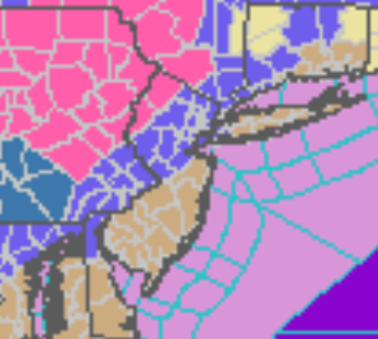
Winter Storm And Wind Warnings And Advisories
|
...WINTER STORM WARNING REMAINS IN EFFECT FROM 6 AM TO 7 PM EST
SATURDAY...

* WHAT...Heavy snow expected. Total snow accumulations of 6 to 8
  inches. Winds gusting as high as 45 mph.

* WHERE...Carbon and Monroe.

* WHEN...From 6 AM to 7 PM EST Saturday.

* IMPACTS...Travel could be very difficult. Areas of blowing
  snow could significantly reduce visibility. Gusty winds could
  bring down tree branches.

PRECAUTIONARY/PREPAREDNESS ACTIONS...

If you must travel, keep an extra flashlight, food, and water in
your vehicle in case of an emergency.
...WINTER STORM WARNING IN EFFECT FROM 6 AM TO 7 PM EST
SATURDAY...

* WHAT...Heavy snow expected. Total snow accumulations of 4 to 6
  inches. Winds gusting as high as 45 mph.

* WHERE...In New Jersey, Sussex and Warren. In Pennsylvania,
  Berks, Lehigh and Northampton.

* WHEN...From 6 AM to 7 PM EST Saturday.

* IMPACTS...Travel could be very difficult. Areas of blowing
  snow could significantly reduce visibility. Gusty winds could
  bring down tree branches.
...WINTER STORM WARNING IN EFFECT FROM 6 AM TO 7 PM EST
SATURDAY...

* WHAT...Heavy snow expected. Total snow accumulations of 4 to 7
  inches. Winds gusting as high as 45 mph.

* WHERE...Orange County.

* WHEN...From 6 AM to 7 PM EST Saturday.

* IMPACTS...Plan on slippery road conditions.
...WINTER STORM WARNING REMAINS IN EFFECT FROM 1 AM TO 7 PM EST
SATURDAY...

* WHAT...Heavy snow expected. Total snow accumulations of 7 to
  12 inches. Winds gusting as high as 40 mph.

* WHERE...In Pennsylvania, Southern Wayne, Pike and Northern
  Wayne counties. In New York, Sullivan, Otsego and Delaware
  counties.

* WHEN...From 1 AM to 7 PM EST Saturday.

* IMPACTS...Travel could be very difficult. Areas of blowing
  snow could significantly reduce visibility.

* ADDITIONAL DETAILS...Heavy snow could produce snowfall rates of
  1-3 inches per hour for a time late tonight through midday
  Saturday.
...WINTER STORM WARNING REMAINS IN EFFECT FROM 1 AM TO 7 PM EST
SATURDAY...

* WHAT...Heavy snow expected. Total snow accumulations of 6 to 10
  inches. Winds gusting as high as 40 mph.

* WHERE...In Pennsylvania, Bradford, Susquehanna, Lackawanna,
  Luzerne and Wyoming counties. In New York, Chenango, Cortland,
  Tompkins, Tioga and Broome counties.

* WHEN...From 1 AM to 7 PM EST Saturday.

* IMPACTS...Travel could be very difficult. Areas of blowing
  snow could significantly reduce visibility.

* ADDITIONAL DETAILS...Heavy snow could produce snowfall rates of
  1-2 inches per hour for a time late tonight into Saturday morning.
...WINTER WEATHER ADVISORY IN EFFECT FROM 6 AM TO 7 PM EST
SATURDAY...

* WHAT...Snow expected. Total snow accumulations of 1 to 3
  inches. Winds gusting as high as 45 mph.

* WHERE...Portions of northern New Jersey, southeast Pennsylvania
  and northern Delaware.

* WHEN...From 6 AM to 7 PM EST Saturday.

* IMPACTS...Plan on slippery road conditions. Gusty winds could
  bring down tree branches.
...WINTER WEATHER ADVISORY IN EFFECT FROM 8 AM TO 7 PM EST
SATURDAY...

* WHAT...Snow expected, along with the refreezing of wet surfaces.
  Total snow accumulations of 2 to 4 inches. Winds gusting as high
  as 45 mph.

* WHERE...Portions of northeast New Jersey, southern Connecticut
  and southeast New York.

* WHEN...From 8 AM to 7 PM EST Saturday.

* IMPACTS...Plan on slippery road conditions.

* ADDITIONAL DETAILS...Temperatures will fall quickly during the
  day Saturday resulting in a quick freezing of any standing
  water resulting in difficult travel.
...WINTER WEATHER ADVISORY IN EFFECT FROM 9 AM TO 7 PM EST
SATURDAY...

* WHAT...Snow expected, along with the refreezing of wet surfaces.
  Total snow accumulations of 1 to 3 inches. Winds gusting as high
  as 50 mph.

* WHERE...Portions of northeast New Jersey, southern Connecticut
  and southeast New York.

* WHEN...From 9 AM to 7 PM EST Saturday.

* IMPACTS...Plan on slippery road conditions. Gusty winds could
  bring down tree branches.

* ADDITIONAL DETAILS...Temperatures will fall quickly during the
  day Saturday resulting in a quick freezing some standing water
  resulting in difficult travel.
...WINTER WEATHER ADVISORY IN EFFECT FROM 9 AM TO 7 PM EST
SATURDAY...

* WHAT...Snow expected, along with the refreezing of wet surfaces.
  Total snow accumulations of 2 to 4 inches. Winds gusting as high
  as 45 mph.

* WHERE...Portions of northeast New Jersey.

* WHEN...From 9 AM to 7 PM EST Saturday.

* IMPACTS...Plan on slippery road conditions.

* ADDITIONAL DETAILS...Temperatures will fall quickly during the
  day Saturday resulting in a quick freezing of any standing
  water resulting in difficult travel.
...WINTER WEATHER ADVISORY REMAINS IN EFFECT FROM 7 AM TO 7 PM
EST SATURDAY...

* WHAT...Snow expected. Total snow accumulations of 2 to 6
  inches. Winds gusting as high as 40 mph.

* WHERE...The Mid Hudson Valley of eastern New York

* WHEN...From 7 AM to 7 PM EST Saturday.

* IMPACTS...Plan on slippery road conditions.

* ADDITIONAL DETAILS...Snow rates may exceed one half inch per
  hour during the day on Saturday.
...WIND ADVISORY IN EFFECT FROM 10 AM SATURDAY TO 1 AM EST
SUNDAY...

* WHAT...Northwest winds 20 to 30 mph with gusts up to 50 mph
  expected.

* WHERE...Portions of New Jersey, southeast Pennsylvania, the
  eastern shores of Maryland and Delaware.

* WHEN...From 10 AM Saturday to 1 AM EST Sunday.

* IMPACTS...Gusty winds could blow around unsecured objects.
  Tree limbs could be blown down and a few power outages may
  result.

* ADDITIONAL DETAILS...Strong winds develop late Staurday morning
  and continue into the afternoon. There may be a lull Saturday
  evening before increasing once again.
...WIND ADVISORY IN EFFECT FROM 11 AM SATURDAY TO MIDNIGHT EST
SATURDAY NIGHT...

* WHAT...Northwest winds 25 to 35 mph with gusts up to 50 mph
  expected.

* WHERE...Northwest Suffolk, Northeast Suffolk, Southwest
  Suffolk, Southeast Suffolk, Northern Nassau and Southern
  Nassau Counties.

* WHEN...From 11 AM Saturday to midnight EST Saturday night.

* IMPACTS...Gusty winds could blow around unsecured objects.
  Tree limbs could be blown down and a few power outages may
  result.

* ADDITIONAL DETAILS...In addition to the wind, rain will change
  over to snow by Saturday afternoon before ending. At least a
  coating of snow is expected for most areas. As temperatures drop
  below freezing by late afternoon into the evening, refreezing
  is possible on some surfaces, creating the potential for
  hazardous travel.
...WIND ADVISORY IN EFFECT FROM 11 AM SATURDAY TO MIDNIGHT EST
SATURDAY NIGHT...

* WHAT...Northwest winds 20 to 30 mph with gusts to around 45 mph
  expected.

* WHERE...Northern Middlesex, Northern New London, Southern New
  Haven, Southern Middlesex and Southern New London Counties.

* WHEN...From 11 AM Saturday to midnight EST Saturday night.

* IMPACTS...Gusty winds could blow around unsecured objects.
  Tree limbs could be blown down and a few power outages may
  result.

* ADDITIONAL DETAILS...In addition to the wind, rain will change
  over to snow by Saturday afternoon before ending. At least a
  coating of snow is expected for most areas. As temperatures drop
  below freezing by late afternoon into the evening, refreezing
  is possible on some surfaces, creating the potential for
  hazardous travel.
More in depth analysis from Meteorologist Steven DiMartino with Premium Consulting Service!
|
|
|