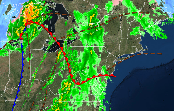
An impressive cold front will bring windy conditions, heavy rainfall, and severe thunderstorms to the region by this afternoon and evening. An active weather pattern continues through next week.
TODAY
A cold front will approach the region with low clouds and isolated showers this morning followed by scattered showers and thunderstorms expected in the afternoon and evening. A few thunderstorms may reach severe levels in eastern Pennsylvania and southwestern New Jersey with intense downpours, frequent lightning, hail, and wind gusts over 65 mph. Winds will be from the south at 10 to 20 mph with gusts over 30 mph outside of the thunderstorms.
Temperatures will rise into the upper 50s to mid-60s along the coast, lower to mid-60s over the interior, and mid-60s to lower 70s in the Delaware River Valley for highs.
TONIGHT
The cold front will move through the region with additional showers and thunderstorms through midnight followed by clearing skies towards morning. Winds will veer to the southwest at 5 to 15 mph. Temperatures will fall into the mid-30s to lower 40s over the interior and mid-40s to lower 50s along the coast for lows.
TOMORROW
A series of troughs will pass through the region with scattered clouds and isolated showers. Winds will be from the west at 10 to 20 mph. Temperatures will rise into the lower to mid-50s over the interior and upper 50s to lower 60s along the coast for highs.
SATURDAY
High pressure will produce scattered cloud cover. An isolated shower is possible throughout the day. Winds will be from the west at 5 to 15 mph. Temperatures will range from the lower to mid-30s over the interior and upper 30s to lower 40s along the coast for lows and lower to mid-40s over the interior and upper 40s to lower 50s along the coast for highs.
SUNDAY
An area of low pressure will pass to the south with scattered clouds and isolated to widely scattered showers. Temperatures will range from the mid-20s over the interior to the mid-30s along the coast for lows and upper 40s to lower 50s over the interior and the lower to mid-50s along the coast for highs.
MONDAY
High pressure will produce clear skies to scattered clouds. Temperatures will range from the lower to mid-30s over the interior and mid to upper 30s along the coast for lows and lower to mid-50s over the interior and mid to upper 50s for highs.
TUESDAY AND WEDNESDAY
A series of weak troughs will pass through the region with scattered clouds and isolated showers. Temperatures on Tuesday will range from the upper 30s to lower 40s for lows and lower to mid-50s on the coast and upper 50s to mid-60s away from the coast for highs. Temperatures on Wednesday will range from the mid to upper 40s for lows and lower to mid-50s for highs.
THURSDAY
An area of low pressure will approach with periods of showers expected by the afternoon and evening hours. Temperatures will range from the mid to upper 40s for lows and lower to mid-50s over the interior, upper 50s to mid-60s in the Delaware River Valley, and mid to upper 50s along the coast for highs.