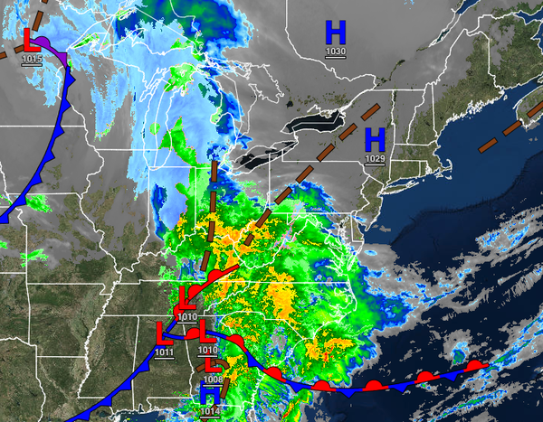
TOMORROW
An area of low pressure will produce periods of rain, heavy at times, in the early morning. Skies will clear towards the afternoon and evening. Winds will be from the northwest at 10 to 20 mph with gusts over 30 mph at times. Temperatures will rise into the lower to mid-40s over the interior and upper 40s to mid-50s along the coast for highs.
WEDNESDAY
High pressure will build into the region with scattered cloud cover. Winds will be from the west at 5 to 10 mph. Temperatures will range from the upper 20s to mid-30s over the interior and upper 30s to lower 40s along the coast for lows and mid-40s to lower 50s over the interior and mid to upper 50s along the coast for highs.
THURSDAY
High pressure will exit the region with increasing cloud cover expected. A cold front will pass through the region in the evening with isolated showers to widely scattered showers. Temperatures will range from the mid to upper 30s over the interior and upper 30s to lower 40s along the coast for lows and mid to upper 50s on the immediate coast, upper 50s to lower 60s over the interior, and lower to mid-60s in the Delaware River Valley for
highs.
FRIDAY
High pressure will remain over the coastal waters with scattered cloud cover expected. Temperatures will range from the lower to mid-40s over the interior and mid to upper 40s along the coast for lows and upper 50s to lower 60s over the interior and mid-60s to lower 70s for highs.
SATURDAY
A cold front will sink south from New England with increasing clouds and isolated showers to widely scattered showers. Temperatures will range from the mid to upper 30s over the interior and lower to mid-40s along the coast for lows and upper 50s to lower 60s along the coast, lower to mid-60s over the interior, and mid to upper 60s in the Delaware River Valley for highs.
SUNDAY
The cold front boundary will stall over the region with scattered to broken cloud cover and isolated showers. Temperatures will range from the mid to upper 40s over the interior and upper 40s to lower 50s along the coast for lows and mid-50s to lower 60s on Long Island and Connecticut, lower to mid-60s along the coast, and upper 60s to mid-70s away from the coast for highs.
MONDAY
A stationary front will produce scattered to broken cloud cover and isolated showers. Temperatures will range from the upper 40s to lower 50s for lows and mid-50s to lower 60s on Long Island and Connecticut and mid-60s to lower 70s for the rest of the region for highs.