...BLIZZARD WARNING IN EFFECT FROM MIDNIGHT TONIGHT TO MIDNIGHT
EST SATURDAY NIGHT...

* WHAT...Blizzard conditions expected. Total snow accumulations of
  15 to 19 inches. Winds gusting as high as 60 mph.

* WHERE...Portions of eastern and northeastern Massachusetts and
  northern and southern Rhode Island.

* WHEN...From midnight tonight to midnight EST Saturday night.

* IMPACTS...Travel could be extremely difficult to impossible.
  Strong winds could cause tree damage.

* ADDITIONAL DETAILS...Considerable blowing and drifting snow
  along with near white out conditions at times. Snowfall rates of
  2 to 4 inches per hour is possible at times.
...BLIZZARD WARNING IN EFFECT FROM 7 PM THIS EVENING TO 7 PM EST
SATURDAY...

* WHAT...Blizzard conditions expected. Total snow accumulations
  of 11 to 15 inches. Winds gusting as high as 60 mph.

* WHERE...In Connecticut, Northern New London and Southern New
  London Counties. In New York, Northeast Suffolk and Southeast
  Suffolk Counties.

* WHEN...From 7 PM this evening to 7 PM EST Saturday.

* IMPACTS...Travel could be very difficult to impossible. The
  hazardous conditions could impact the evening commute. Strong
  winds could cause tree damage.

* ADDITIONAL DETAILS...Blizzard conditions are expected Saturday
  morning into early Saturday afternoon. White out conditions are
  likely at times.
...BLIZZARD WARNING IN EFFECT FROM 7 PM THIS EVENING TO 7 PM EST
SATURDAY...

* WHAT...Blizzard conditions expected. Total snow accumulations
  of 11 to 15 inches. Winds gusting as high as 50 mph.

* WHERE...Northwest Suffolk and Southwest Suffolk Counties.

* WHEN...From 7 PM this evening to 7 PM EST Saturday.

* IMPACTS...Travel could be very difficult to impossible. The
  hazardous conditions could impact the evening commute. Gusty
  winds could bring down tree branches.

* ADDITIONAL DETAILS...Blizzard conditions are expected Saturday
  morning into early Saturday afternoon. White out conditions are
  likely at times.
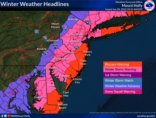
...BLIZZARD WARNING IN EFFECT FROM 7 PM THIS EVENING TO 7 PM EST
SATURDAY...

* WHAT...Blizzard conditions expected. Total snow accumulations of
  8 to 15 inches. Winds gusting as high as 50 mph.

* WHERE...The coastal counties of New Jersey, and coastal sections
  of Sussex County in Delaware.

* WHEN...From 7 PM this evening to 7 PM EST Saturday.

* IMPACTS...Travel could be very difficult to impossible. Areas
  of blowing snow could significantly reduce visibility. Gusty
  winds could bring down tree branches.

* ADDITIONAL DETAILS...Snow is expected to begin on Friday
  evening, with snow becoming heavy after midnight. The most
  likely time for blizzard conditions is late Friday night through
  midday Saturday. Blizzard conditions are primarily expected at
  or within a few miles from the coast. Snow will wind down
  Saturday afternoon.