A cold front will bring an end to the active weather pattern, but not without producing showers and thunderstorms this afternoon and evening.
TODAY
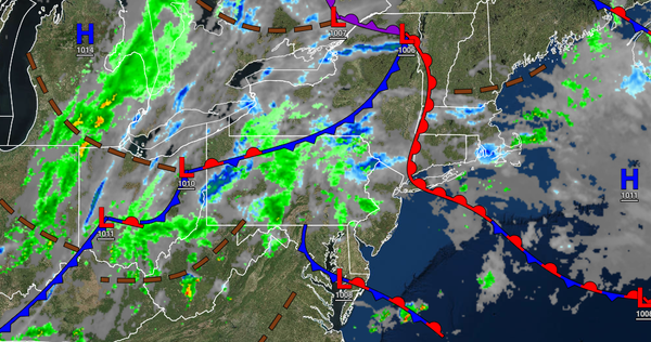
A stalling back-door cold front will produce scattered to broken cloud cover with isolated to scattered showers throughout the region in the morning. A strong cold front will approach with widespread showers and thunderstorms in the afternoon and evening. A few thunderstorms will be capable of intense downpours, frequent lightning, hail, wind gusts over 50 mph, and an isolated tornado. The highest threat for severe thunderstorms will be around and
south of the Philadelphia metropolitan area. Winds will be from the east at 5 to 15 mph along the coast and in Connecticut and from the southwest at 5 to 15 mph away from the coast. Temperatures will rise into the lower to mid-70s along the coast and upper 70s to mid-80s away from the coast for highs.
TONIGHT
The cold front will clear the region with lingering showers and thunderstorms through the early morning hours. Skies will clear towards morning. Winds will veer to the northwest at 5 to 15 mph. Temperatures will fall into the lower to mid-60s for lows.
TOMORROW
High pressure will build into the region with clearing skies and much lower humidity. Winds will be from the northwest at 5 to 15 mph. Temperatures will rise into the lower to mid-70s over the interior, mid to upper 70s along the coast, and upper 70s to lower 80s in the Delaware River Valley for highs.
SATURDAY
A trough will linger over the region with scattered clouds. Winds will be from the northwest at 5 to 5 mph. Temperatures will range from the lower to mid-50s for lows and upper 60s to lower 70s along the coast, lower to mid-70s over the interior, and mid to upper 70s in the Delaware River Valley for highs.
SUNDAY
A weak trough will produce scattered clouds. Temperatures will range from the lower to mid-50s for lows and upper 60s to lower 70s along the coast, lower to mid-70s over the interior, and mid to upper 70s in the Delaware River Valley for highs.
MONDAY AND TUESDAY
High pressure will produce clear skies to scattered clouds. Temperatures on Monday will range from the upper 40s to lower 50s over the interior and lower to mid-50s along the coast for lows and upper 60s to lower 70s along the coast and mid to upper 70s away from the coast for highs. Temperatures on Tuesday will range from the upper 40s to mid-50s over the interior and mid to upper 50s along the coast for lows and upper 60s to lower 70s along the coast,
mid to upper 70s over the interior, and mid-70s to lower 80s in the Delaware River Valley for highs.
WEDNESDAY
A strong cold front will move through the region with showers and thunderstorms in the morning followed by clearing skies in the afternoon. Temperatures will range from the mid-50s to lower 60s for lows and lower to mid-70s over the interior, mid to upper 70s on the coast, and upper 70s to lower 80s in the Delaware River Valley.
THURSDAY
A weak cold front will follow with a few widely scattered showers. Temperatures will range from the lower to mid-50s over the interior and upper 50s to lower 60s along the coast for lows and mid to upper 70s over the interior, upper 70s to lower 80s along the coast, and lower to mid-80s in the Delaware River Valley for highs.