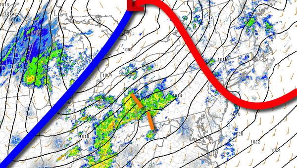
Unseasonably warm conditions will develop this afternoon ahead of a strong cold front. Showers and thunderstorms are a threat this evening.
Areas of fog, low clouds, and drizzle this morning will give way to clearing skies this afternoon ahead of a cold front. Scattered showers and isolated thunderstorms will be a threat this evening. The thunderstorms will be capable of brief heavy downpours, isolated lighting strikes, and wind gusts up to 40 mph. Winds will be from the southwest at 10 to 20 mph. Temperatures will
rise into the mid-60s to lower 70s on Long Island and mid to upper 70s elsewhere for highs.
The cold front will exit tonight with lingering showers followed by clearing skies. Winds will veer to the northwest at 5 to 15 mph. Temperatures will fall into the lower to mid-30s over the interior and upper 30s to lower 40s along the coast for lows.
High pressure will be in control tomorrow on through Sunday with clear skies to scattered cloud cover. Winds will veer from the north to northeast at 5 to 10 mph. Temperatures tomorrow will rise into the mid-40s to lower 50s for highs. Temperatures on Sunday will range from the lower to mid-20s over the interior and upper 20s to lower 30s along the coast for lows and lower to mid-40s for highs.
An area of low pressure will approach on Monday with a wintry mix of snow and rain over the interior and rain along the coast. Some snow accumulation is possible for higher elevations. Heavy rain is expected along the coast. Temperatures on Monday will range from the lower to mid-30s over the interior and upper 30s to lower 40s along the coast for lows and mid to upper 30s over the interior and lower 40s to mid-50s along the coast for
highs.
Rain and snow showers will linger into Tuesday morning followed by clearing skies. Temperatures will range from the mid to upper 30s for lows and upper 40s to mid-50s for highs.
A cold front will follow on Wednesday with scattered showers expected. Temperatures on Wednesday will range from the mid-30s to lower 40s for lows and mid-40s to lower 50s for highs.
High pressure will produce scattered cloud cover on Thursday. Temperatures will range from the mid-30s to lower 40s for lows and mid to uper 50s for highs.