As an area of low pressure lifts through the Great Lakes through tomorrow with periods of showers, heavy at times. Weather pattern now expected to relax through next week.
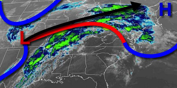
A warm front will lift towards the region today with periods of showers, heavy at times. Winds will be from the east at 5 to 15 mph. Temperatures will rise into the upper 40s to mid-50s for highs.
The warm front will lift through the region tonight with periods of showers, heavy at times. Winds will veer to the southeast at 5 to 15 mph. Temperatures will fall into the mid-40s to lower 50s for lows.
A cold front will follow by tomorrow afternoon with periods of showers and isolated thunderstorms. The thunderstorms will be capable of brief heavy downpours, occasional lightning, and wind gusts up to 40 mph. Temperatures will rise into the upper 40s to lower 50s over the interior, mid to upper 50s in the New York City Metro, and upper 50s to mid-60s in the Philadelphia metro for highs.
High pressure will build into the region tomorrow night through Monday with clearing skies. Winds will veer to the west at 5 to 15 mph. Temperatures will range from the mid to upper 40s for lows and lower to mid-60s over the interior and mid to upper 60s along the coast.
A series of weak cold fronts will follow on Tuesday and Wednesday with scattered cloud cover and isolated showers. Temperatures on Tuesday will range from the mid-30s to lower 40s for lows and mid-40s to lower 50s for highs. Temperatures on Wednesday will range from the upper 30s to lower 40s for lows and upper 40s to lower 50s for highs.
High pressure will produce clear skies to scattered cloud cover on Thursday and Friday. Temperatures on Thursday will range from the lower to mid-30s over the interior and mid to upper 30s along the coast for lows and mid-50s to lower 60s for highs. Temperatures on Friday will range from the upper 30s to lower 40s over the interior and mid to upper 40s along the coast for lows and mid-50s to lower 60s for highs.