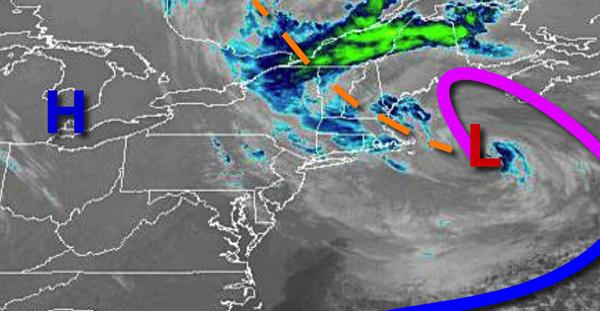
A trough of low pressure will produce periods of showers today, but excellent weather is expected for the weekend.
As a trough of low pressure rotates from New England on through the region, broken to overcast clouds and scattered showers can be expected. Winds will veer from the northwest to north at 5 to 15 mph. Temperatures will rise into the upper 40s to lower 50s for highs today.
High pressure will be in control tomorrow on through Sunday with clear skies to scattered cloud cover. Wilds will back from the north to west at 5 to 10 mph. Temperatures tomorrow will range from the lower to mid-40s for lows and mid to upper 50s for highs. Temperatures on Sunday will range from the upper 30s for lows and upper 50s to mid-60s for highs.
A cold front will move through the region on Monday morning with a few isolated showers followed by clearing skies in the afternoon.
Temperatures on Monday will range from the lower to mid-30s over the interior and upper 30s to mid-40s along the coast for lows and upper 50s to mid-60s for highs.
A warm front will approach the region on Tuesday and Wednesday with broken clouds and isolated to widely scattered showers. Temperatures on Tuesday will range from the lower to mid-40s over the interior and upper 40s to lower 50s along the coast for lows and lower to mid-60s over the interior and mid to upper 60s along the coast for highs. Temperatures on Wednesday will range from the lower to mid-30s over the interior and upper 30s to
lower 40s along the coast for lows and lower to mid-40s for highs.
The warm front will lift north on Thursday morning followed by the cold front in the afternoon with scattered showers and isolated thunderstorms. Temperatures on Thursday will range from the upper 20s to mid-30s for lows and upper 40s to lower 50s over the interior and mid-50s to lower 60s along the coast.