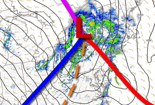
A strong area of low pressure will produce showers and strong to severe thunderstorms through this afternoon. Windy conditions are expected by tomorrow.
As an area of low pressure lifts into New England through this afternoon which will drive a warm front northward this morning and drive the cold front to the coast with showers and strong to severe thunderstorms. Severe thunderstorms, though isolated, will be capable of intense downpours, frequent lightning, small hail, wind gust over 60 mph, and even an isolated tornado. These thunderstorms will be capable of major ponding on the roadways,
visibility below a mile, and wind damage. Power outages are a threat. Winds will back from southeast to northwest at 15 to 25 mph with gusts over 30 mph. Temperatures will rise into the mid to upper 50s over the interior, upper 50s to mid-60s in the New York City metro, and mid-60s to lower 70s in the Philadelphia metro for highs.
As the low-pressure system slowly leaves the region tonight through tomorrow, scattered clouds and isolated showers can be expected. A few snow showers are possible for the highest elevations. Winds will be from the northwest at 15 to 25 mph with gusts over 30 mph. Temperatures will range from the mid-30s to lower 40s for lows and mid-40s to lower 50s for highs.
High pressure will build into the region on Saturday with clearing skies. Winds will be from the northwest at 10 to 20 mph. Temperatures will range from the lower to mid-30s over the interior and mid to upper 30s along the coast for lows and lower to mid-50s for highs.
An area of low pressure will approach on Sunday with increasing clouds with rain by the evening. Periods of rain, heavy at times, will continue Sunday night through Monday afternoon. Temperatures on Sunday will range from the lower to mid-30s over the interior and upper 30s to lower 40s along the coast for lows and lower to mid-60s for highs. Temperatures on Monday will range from the lower to mid-50s for lows and upper 60s to mid-70s
for highs.
A series of weak cold fronts will follow on Tuesday and Wednesday with scattered clouds and isolated showers. Temperatures on Tuesday will range from the upper 30s to mid-40s for lows and lower to mid-50s for highs. Temperatures on Wednesday will range from the mid to upper 30s for lows and lower to mid-40s for highs.