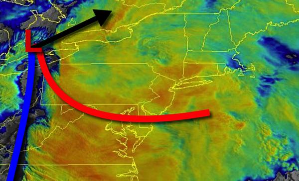
Heavy rain, strong to severe thunderstorms, and powerful wind gusts are expected through this afternoon as a powerful cold front drives through the region.
Periods of rain and strong to severe thunderstorms are expected through this afternoon. The strongest thunderstorms will be capable of intense downpours, frequent lightning, small hail, wind gusts over 60 mph, and isolated tornadoes. Winds will be from the south at 15 to 30 mph with gusts over 40 mph at times. Temperatures will rise into the lower to mid-60s on Long Island and mid-60s to lower 70s elsewhere for highs.
The cold front will clear the region this evening with clearing skies tonight on through tomorrow morning. Winds will veer to the west at 5 to 15 mph. Temperatures will fall into the upper 30s to mid-40s for lows.
High pressure will build into the region tomorrow with clear skies to scattered cloud cover. Winds will be from the west at 5 to 15 mph. Temperatures will rise into the lower to mid-50s over the interior and mid-50s to lower 60s elsewhere for highs.
An area of low pressure will produce periods of showers, heavy at times. winds will be from the west at 5 to 10 mph. Temperatures will range from the lower to mid-30s over the interior and upper 30s to lower 40s along the coast for lows and upper 40s to mid-50s for highs.
High pressure will produce scattered cloud cover on Thursday and Friday. Temperatures on Thursday will range from the lower to mid-30s over the interior and mid to upper 30s along the coast for lows and upper 40s to mid-50s for highs. Temperatures on Friday will range from the upper 20s to mid-30s for lows and mid-40s to lower 50s over the interior and mid to upper 50s along the coast for highs.
An area of low pressure will produce periods of rain on Saturday. Temperatures on Saturday will range from the mid-30s to lower 40s for lows and upper 30s to mid-40s over the interior, mid-40s to lower 50s in the New York City metro, and lower to mid-50s in the Philadelphia metro for highs.
High pressure will produce scattered cloud cover on Sunday. Temperatures on Sunday will range from the mid-30s to lower 40s for lows and mid-50s to lower 60s on Long Island and lower to mid-60s elsewhere for highs.