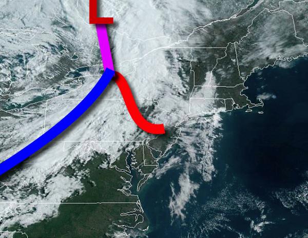
A cold front will move through the region today with showers and strong to severe thunderstorms expected this afternoon. Chilly weather conditions return tomorrow with freezing conditions by tomorrow morning.
Scattered clouds this morning will give way to showers and strong to severe thunderstorms this afternoon. The thunderstorms are expected to develop by noon and move through the region through 6 PM this evening. The thunderstorms will be capable of heavy downpours, frequent lightning, hail, and wind gusts over 60 mph. Winds will veer from the southwest to northwest at 10 to 20 mph with gusts over 40 mph at times. Temperatures will
rise into the mid to upper 50s on Long Island and upper 50s to mid-60s elsewhere for highs.
High pressure will build into the region tonight with clearing skies. Winds will veer to the northwest at 5 to 15 mph with gusts over 30 mph at times. Temperatures will fall into the upper 20s to mid-30s for lows.
High pressure will pass over the region tomorrow with scattered cloud cover. Winds will be from the northwest at 10 to 20 mph. Temperatures will rise into the mid-40s to lower 50s for highs.
An area of low pressure will approach the region on Thursday with increasing clouds and showers by evening. Winds will veer from the northwest to north at 5 to 10 mph. Temperatures will range from the upper 20s to mid-30s for lows and upper 40s to lower 50s for highs.
An area of low pressure will produce periods of showers on Friday. Temperatures on Friday will range from the upper 30s to lower 40s over the interior and mid to upper 40s along the coast for lows and upper 40s to lower 50s for highs.
A series of weak low-pressure troughs will produce scattered to broken cloud cover and isolated to widely scattered showers on Saturday. Temperatures on Saturday will range from the upper 20s to mid-30s for lows and upper 50s to lower 60s for highs.
A stronger low-pressure system will produce periods of rain on Sunday. Temperatures on Sunday will range from the lower to mid-40s over the interior and upper 40s to lower 50s along the coast for lows and mid-40s to lower 50s over the interior, mid-50s to lower 60s in the New York City metro, and mid-60s to lower 70s in the Philadelphia metro for highs.
A series of weak troughs will produce scattered to broken clouds and isolated showers on Monday. Temperatures will range from the upper 30s to lower 40s over the interior and mid to upper 40s along the coast for lows and upper 40s to mid-50s for highs.