An active weather pattern will continue on through next weekend with plenty of clouds and threats for rainfall.
A cold front will clear the region today with broken to overcast cloud cover and isolated to widely scattered showers. Winds will veer to the north at 5 to 10 mph. Temperatures will rise into the lower to mid-50s for highs.
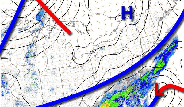
Another cold front will follow tomorrow with scattered to broken cloud cover and scattered showers and thunderstorms, especially in the afternoon. The thunderstorms will be capable of heavy downpours, occasional to frequent lightning, hail, and wind gusts over 60 mph. Winds will veer from the southwest to northwest at 10 to 20 mph. Temperatures will range from the mid to upper 30s over the interior and lower to mid-40s along the coast
for lows and mid to upper 50s over the interior and upper 50s to mid-60s along the coast for highs.
High pressure will be in control on Wednesday with clear skies to scattered cloud cover. Winds will be from the northwest at 10 to 20 mph. Temperatures will range from the upper 20s to mid-30s for lows and mid to upper 40s over the interior and lower to mid-50s along the coast for highs.
An area of low pressure will approach on Thursday with increasing clouds and showers towards evening. Temperatures will range from the upper 20s to mid-30s over the interior and upper 30s to mid-40s along the coast for lows and lower to mid-50s for highs.
A series of low-pressure systems will produce scattered to broken cloud cover and scattered showers for Friday on through Sunday. Temperatures on Friday will range from the upper 30s to lower 40s over the interior and mid to upper 40s along the coast for lows and mid-50s to lower 60s for highs. Temperatures on Saturday will range from the mid-30s to lower 40s for lows and mid to upper 50s for highs. Temperatures on Sunday will range from
the lower to mid-40s over the interior and mid to upper 40s along the coast for lows and lower to mid-50s over the interior and mid-50s to lower 60s along the coast for highs.