Periods of showers and heavy rain can be expected through tomorrow morning with embedded thunderstorms and powerful wind gusts. Improving conditions expected by this weekend.
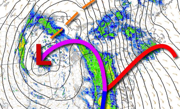
A cold front will slowly approach the region while a warm front lifts north with periods of showers through this afternoon. Winds will be from the southeast at 10 to 20 mph. Temperatures will rise into the upper 50s to mid-60s for highs this afternoon.
The cold front will move through the region tonight with waves of heavy rainfall and embedded thunderstorms. The thunderstorms will feature intense downpours, occasional lightning, small hail, and wind gusts over 60 mph. Winds will veer from the southeast to west at 10 to 20 mph with gusts over 40 mph. Temperatures will fall into the lower to mid-50s for lows.
Showers and broken clouds will linger through tomorrow as the low-pressure system slowly exits into the Atlantic. Winds will be from the northwest at 10 to 20 mph. Temperatures will rise into the lower to mid-60s over the interior and upper 60s to lower 70s along the coast for highs.
High pressure will build into the region on Saturday with lingering showers in the morning followed by clearing skies towards the afternoon. Winds will be from the northwest at 10 to 20 mph. Temperatures will range from the mid-40s to lower 50s for lows and mid-60s to lower 70s for highs.
High pressure will exit on Sunday with increasing clouds towards the afternoon. Temperatures will range from the mid-40s to lower 50s for lows and lower to mid-60s on Long Island and upper 60s to mid-70s elsewhere for highs.
A series of cold fronts and low-pressure troughs will pass through the region Monday on through Wednesday with scattered to broken cloud cover and isolated showers. Temperatures on Monday will range from the upper 40s to mid-50s for lows and upper 50s to lower 60s for highs. Temperatures on Tuesday will range from the lower to mid-40s for lows and upper 50s to lower 60s for highs. Temperatures on Wednesday will range from the lower to
mid-30s over the interior and mid to upper 30s along the coast for lows and upper 50s to lower 60s for highs.