Warm weather conditions will return today, but so will some showers. A cool, wet weather pattern returns once again for next week.
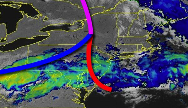
A warm front will continue to lift through the region today with scattered to broken cloud cover and scattered showers. Winds will be from the west at 5 to 15 mph. Temperatures will rise into the upper 60s to mid-70s for highs this afternoon.
A cold front will follow tonight on through tomorrow morning with periods of showers. Heavier downpours are expected over southern New Jersey where up to one inch of rain is possible. Winds will be from the west at 5 to 10 mph. Temperatures will fall into the mid to upper 40s over the interior, upper 40s to lower 50s in the New York City Metro, and mid to upper 50s in the Philadelphia metro for lows.
Another cold front will follow tomorrow afternoon with scattered to broken cloud cover and isolated showers. Winds will be from the northwest at 10 to 20 mph. Temperatures will rise into the mid to upper 50s over the interior, upper 50s to lower 60s in the New York City metro, and mid to upper 60s in the Philadelphia metro for highs.
Another weak cold front will follow on Tuesday with scattered clouds and isolated showers. Winds will be from the northwest at 5 to 10 mph. Temperatures will range from the mid-30s to lower 40s for lows and mid-50s to lower 60s for highs.
A series of cold fronts and troughs will follow Wednesday on through Friday with scattered to broken cloud cover and isolated showers. Temperatures on Wednesday will range from the upper 30s to lower 40s over the interior and mid to upper 40s along the coast for lows and lower to mid-50s over the interior and mid to upper 50s along the coast for highs. Temperatures on Thursday will range from the mid-30 to the lower 40s over the interior
and lower to mid-40s along the coast for lows and mid to upper 50s for highs. Temperatures on Friday will range from the upper 30s to mid-40s for lows and upper 50s to mid-60s for highs.
High pressure will build into the region on Saturday with scattered to broken cloud cover. Temperatures will range from the lower to mid-30s over the interior and upper 30s to lower 40s for lows and lower to mid-40s over the interior and mid to upper 40s along the coast for highs.