More sunshine expected today, but rain and snow returns by tomorrow. Very chilly weather conditions will be in place by the weekend.
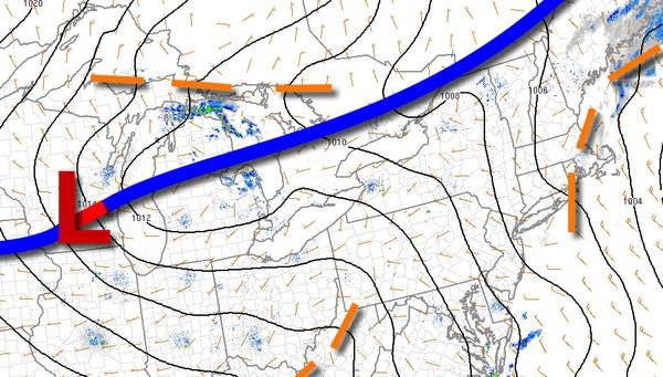
A weak cold front will pass through the region by this afternoon with scattered cloud cover and isolated showers. Winds will be from the west at 5 to 15 mph. Temperatures will rise into the upper 50s to mid-60s for highs.
An area of low pressure will approach tonight with increasing clouds and isolated showers. Winds will be from the west at 5 to 10 mph. Temperatures will fall into the mid to upper 30s over the interior and lower to mid-40s along the coast for lows.
An area of low pressure will move through the region with periods of rain throughout the region in the afternoon. Snow will mix in with the rain over the higher elevations of the Poconos and Catskills. Snow accumulation for the higher elevation on cold surfaces will range from 1" to 3". Winds back from the southwest to northeast at 5 to 15 mph. Temperatures will rise into the upper 40s to lower 50s over the interior and
mid-50s to lower 60s along the coast for highs.
Rain will linger through Saturday morning while snow will taper off over the higher elevations. Winds will back to the northwest at 10 to 20 mph with gusts over 25 mph. Temperatures on Saturday morning will range from the upper 20s to mid-30s for lows.
As the storm exits on Saturday, skies will clear and isolated snow showers over the Poconos and Catskills. Winds will be from the northwest at 10 to 20 mph with gusts over 30 mph. Temperatures on Saturday will rise into the upper 30s to lower 40s over the interior and mid to upper 40s along the coast for highs.
High pressure will pass over the region on Sunday with clear skies to scattered cloud cover. Temperatures on Sunday will range from the upper 20s to mid-30s for lows and upper 40s to lower 50s over the interior and mid to upper 50s along the coast for highs.
A cold front will follow on Monday with scattered clouds and isolated showers. Temperatures on Monday will range from the upper 30s to lower 40s for lows and mid-50s to lower 60s for highs.
High pressure will produce clear skies to scattered cloud cover on Tuesday and Wednesday. Temperatures on Tuesday will range from the lower to mid-30s over the interior and upper 30s to lower 40s along the coast for lows and lower to mid-50s for highs. Temperatures on Wednesday will range from the lower to mid-30s over the interior and mid to upper 30s along the coast for lows and lower to mid-50s over the interior and mid to upper 50s
along the coast for highs.