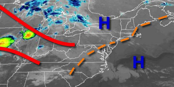
A warm front moving through the region this evening will mark the return of an active weather pattern for the region. The threat of waves of showers throughout much of next week is growing.
High pressure will exit today as a warm front approaches from the Tennessee River Valley which will produce increasing clouds throughout the day. Winds will develop out of the south at 5 to 15 mph. Temperatures will rise into the lower to mid-60s on Long Island and mid to upper 60s elsewhere for highs.
The warm front will move through the region tonight on through tomorrow morning with broken cloud cover and isolated to widely scattered showers. Winds will veer to the southwest at 5 to 15 mph. Temperatures tomorrow morning will fall into the lower to mid-50s over the interior and Long Island, mid-50s to lower 60s elsewhere for lows.
A cold front will approach the region tomorrow with scattered cloud cover through the afternoon and isolated showers and thunderstorms developing. As the cold front approaches towards evening, widespread showers and thunderstorms can be expected to the north and west of the Philadelphia and New York City metropolitan areas. The thunderstorms will be capable of heavy downpours, occasional lightning, hail, and wind gusts over 40 mph. Winds
will be from the southwest at 5 to 15 mph. Temperatures will rise into the lower to mid-70s on Long Island, mid to upper 70s over the interior, and upper 70s to mid-80s elsewhere for highs.
The cold front will move through the region tomorrow night with scattered showers and isolated thunderstorms. The thunderstorms will be capable of isolated to occasional lightning strikes, heavy downpours, and wind gusts up to 40 mph. Winds will veer from the southwest to northwest at 5 to 15 mph. Temperatures will fall into the mid to upper 50s over the interior and upper 50s to mid-60s along the coast for lows.
The cold front will linger over the region on Saturday with scattered to broken cloud cover and isolated showers. Winds will veer to the north at 5 to 15 mph. Temperatures will rise into the lower to mid-70s for highs.
An onshore flow will develop on Sunday with broken to overcast cloud cover and isolated showers and drizzle. Temperatures on Sunday will range from the upper 40s to mid-50s for lows and upper 50s to mid-60s for highs.
An area of low pressure will approach from the Ohio River Valley on Monday with overcast skies and isolated to widely scattered showers through the afternoon. The showers will become widespread by evening. Temperatures on Monday will range from the upper 40s to lower 50s over the interior and New York City metro and mid to upper 50s in the Philadelphia metro for lows and lower to mid-60s over the interior and New York City metro and upper 60s
to mid-70s in the Philadelphia metro for highs.
The area of low pressure will linger over the region Monday night on through Wednesday with periods of showers, heavy at times, along with drizzle. Temperatures on Tuesday will range from the upper 40s to mid-50s for lows and mid to upper 50s for highs. Temperatures on Wednesday will range from the upper 40s to lower 50s for lows and lower to mid-50s over the interior and the New York City metro and mid-50s to lower 60s in the Philadelphia
metro for highs.