After some morning showers, summer-like weather conditions will return for this afternoon. A cold front this evening will bring showers and thunderstorms tonight followed by an unsettled and wet weather pattern through next week.
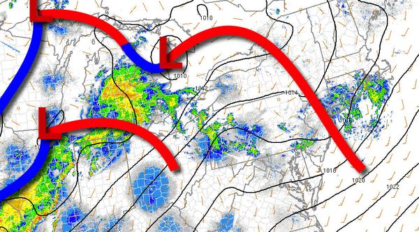
The warm front will continue to lift to the north this morning with overcast skies and scattered showers. As the warm front lifts north, scattered cloud cover can be expected this afternoon with an isolated shower or thunderstorms. Winds will be from the southwest at 5 to 15 mph. Temperatures will rise into the mid to upper 70s on Long Island and upper 70s to mid-80s elsewhere for highs.
A cold front will drop south this evening through tomorrow morning with showers and thunderstorms. The strongest thunderstorms are expected over northeastern Pennsylvania, the Catskills and Hudson River Valley, and northern Connecticut with intense downpours, frequent lightning, hail, and wind gusts over 60 mph this evening. Showers and thunderstorms will drop south tonight but will be weakening. Still, the thunderstorms will be capable
of heavy downpours, occasional lightning, and wind gusts over 40 mph. Winds will veer to the west at 5 to 15 mph. Temperatures will fall into the lower to mid-50s over the interior and upper 50s to mid-60s along the coast for lows.
The cold front will stall and linger over the region tomorrow with scattered to broken clouds and isolated showers. Winds will be from the north at 5 to 15 mph. Temperatures will rise into the lower to mid-70s over the interior and New York City metro and mid to upper 70s in the Philadelphia metro for highs.
By Sunday, high pressure will move towards the Gulf of Maine while the old cold front boundary will stall just southwest of the region which will produce scattered to broken cloud cover and isolated showers. Winds will veer to the east at 5 to 15 mph. Temperatures on Sunday will range from the upper 40s to lower 50s for lows and lower to mid-60s for highs.
An area of low pressure will approach from the west on Monday with widely scattered showers in the morning, becoming widespread by the afternoon and evening. Temperatures on Monday will range from the lower to mid-50s for lows and upper 50s to mid-60s over the interior and New York City metro and mid-60s to lower 70s in the Philadelphia metro for highs.
The area of low pressure will intensify and stall over the Delmarva Peninsula Tuesday on through Thursday with periods of rain rotating in from the Atlantic Ocean into the coast. The rain will be heavy at times with total rainfall amounts exceeding 2" in many locations. Areas of flooding will be a concern. Wind will be from the east and range from 15 to 30 mph with higher gusts. Temperatures on Tuesday will range from the mid-40s
to lower 50s for lows and upper 40s to lower 50s for highs. Temperatures on Wednesday will range from the lower to mid-40s over the interior and mid to upper 40s along the coast for lows and mid to upper 50s for highs. Temperatures on Thursday will range from the lower to mid-40s for lows and lower to mid-50s on the coast and mid to upper 50s over the interior for highs.