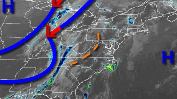
A cold front will bring showers and thunderstorms to the region today after the fog lifts. Cool conditions return to the region by tomorrow night.
Areas of fog and isolated showers will give way to scattered to broken cloud cover by this afternoon. A cold front will approach the region with scattered showers and thunderstorms developing in the afternoon and evening hours. The strongest thunderstorms will be over eastern Pennsylvania and will be capable of intense downpours, frequent lightning, hail, wind gusts over 60 mph, and isolated tornadoes. Winds will be from the southwest at
5 to 15 mph. Temperatures will rise into the mid-60s to lower 70s on Long Island and mid-70s to lower 80s elsewhere for highs.
The cold front will move through the region tonight on through tomorrow morning with scattered showers and isolated thunderstorms. The thunderstorms will be capable of brief heavy downpours, small hail, isolated lightning strikes, and wind gusts over 40 mph. Winds will veer from the southwest to the west at 5 to 15 mph. Temperatures will fall into the lower to mid-60s over the interior and New York City metro and mid to upper 60s in the
Philadelphia metro and southern New Jersey for lows.
The cold front will clear the coast tomorrow morning with a few lingering showers followed by clearing skies. Winds will be from the west at 5 to 15 mph. Temperatures will rise into the lower to mid-70s over the interior and mid-70s to lower 80s along the coast for highs.
High pressure will produce clear skies to scattered cloud cover on Sunday. Winds will be from the northwest at 5 to 15 mph. Temperatures on Sunday will range from the mid-40s to lower 50s over the interior and mid to upper 50s along the coast for lows and mid-50s to lower 60s over the interior and mid to upper 60s along the coast for highs.
High pressure will pass over the region on Monday with clear skies to scattered cloud cover. Temperatures on Monday will range from the upper 30s to lower 40s over the interior and mid to upper 40s along the coast for lows and lower to mid-60s for highs.
An area of low pressure will move through the region on Tuesday and Wednesday with scattered to broken clouds and isolated to widely scattered showers. Temperatures on Tuesday will range from the lower to mid-40s over the interior and mid to upper 40s along the coast for lows and lower to mid-60s on Long Island and mid to upper 60s elsewhere for highs. Temperatures on Wednesday will range from the lower to mid-50s over the interior and upper
50s to lower 60s along the coast for lows and upper 70s to lower 80s over the interior, lower to mid-80s in the New York City metro, and mid to upper 80s in the Philadelphia metro for highs.
High pressure will produce clear skies to scattered cloud cover on Thursday. Temperatures on Thursday will range from the mid to upper 50s over the interior, lower to mid-60s on Long Island, and mid to upper 60s elsewhere for lows and upper 70s to lower 80s for highs.