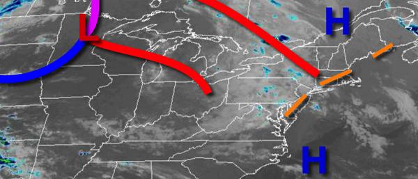
A warm front will be on the move today with increasing clouds and showers by this evening. Summer heat returns tomorrow with some locations in the mid-80s to lower 90s. Thunderstorms follow in the evening.
A warm front will approach the region today with increasing clouds and isolated showers by the afternoon. Winds will be from the southwest at 5 to 15 mph. Temperatures will rise into the upper 60s to lower 70s for highs.
The warm front will move through the region tonight with broken to overcast cloud cover, fog, and scattered showers. Winds will be from the southwest at 5 to 15 mph. Temperatures will fall into the upper 50s to lower 60s for lows.
A cold front will follow tomorrow afternoon and evening with scattered clouds giving way to scattered showers and strong to severe thunderstorms. The strongest thunderstorms will be capable of producing intense downpours, hail, frequent lightning, and wind gusts over 60 mph. Winds will veer from the southwest to the west at 5 to 15 mph. Temperatures will rise into the mid-70s to lower 80s on Long Island and mid-80s to lower 90s elsewhere
for highs.
High pressure will produce scattered cloud cover on Thursday. Temperatures on Thursday will range from the upper 50s to mid-60s for lows and upper 70s to mid-80s for highs.
An area of low pressure will produce scattered showers on Friday. Temperatures on Friday will range from the upper 50s to lower 60s for lows and upper 70s to mid-80s for highs.
A cold front will exit in the morning hours on Saturday with isolated showers followed by scattered cloud cover. Another cold front will follow on Sunday with isolated showers. Temperatures on Saturday will range from the mid to upper 60s for lows and lower to mid-80s for highs. Temperatures on Sunday will range from the mid-50s to lower 60s for lows and mid to upper 70s for highs.
High pressure will produce clear skies to scattered cloud cover on Monday. Temperatures will range from the lower to mid-50s for lows and mid to upper 70s for highs.
Please visit the Local Seven Day Forecast for details for your specific location!