A cool, tranquil maritime air mass will remain in control through tomorrow. A more unsettled weather pattern is expected by this weekend.
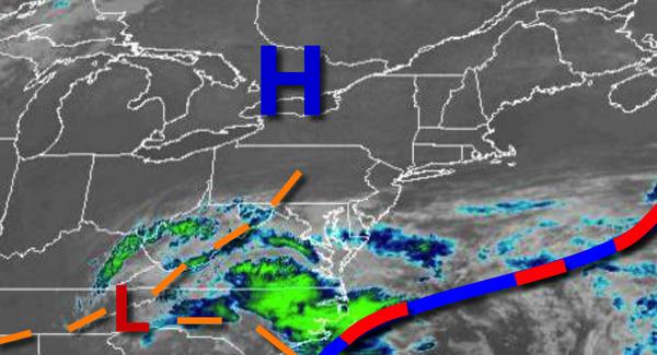
High pressure to the north of the region and a low-pressure system to the south will continue to produce scattered to broken cloud cover through tomorrow. An isolated shower is possible but unlikely. Winds will be from the northeast at 5 to 15 mph. Temperatures will rise into the lower to mid-70s for highs today. Temperatures tomorrow will range from the lower to mid-50s for lows and mid to upper 70s for highs.
The area of low pressure will drift closer to the region from the Tennessee River Valley with increasing cloud cover and isolated to widely scattered showers on Thursday. Winds will be from the east at 5 to 15 mph. Temperatures on Thursday will range from the upper 50s to lower 60s for lows and mid to upper 70s for highs.
The area of low pressure will slowly drift through the region Friday on through Monday with scattered to broken cloud cover and isolated to widely scattered showers and thunderstorms. Temperatures on Friday will range from the lower to mid-60s for lows and upper 70s to mid-80s for highs. Temperatures on Saturday will range from the upper 50s to mid-60s for lows and upper 70s to lower 80s for highs. Temperatures on Sunday will range from
the mid to upper 60s for lows and upper 70s to lower 80s for highs. Temperatures on Monday will range from the mid to upper 60s for lows and mid-70s to lower 80s on the coast and mid-80s to lower 90s elsewhere for highs.
For details on your location please visit the Seven Day Forecast!