Very comfortable weather conditions are in place to start the week, but hot and humid weather returns by next weekend.
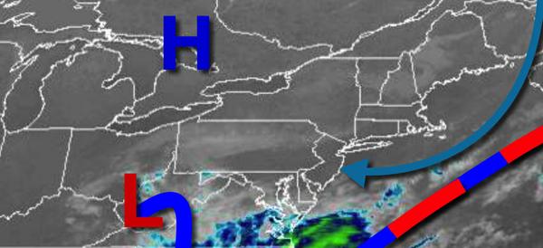
High pressure will remain in control today on through Wednesday with clear skies to scattered cloud cover. An isolated shower is possible but not likely through the forecast period. Winds will be from the east-northeast at 5 to 15 mph. Temperatures will rise into the upper 60s to mid-70s for highs today. Temperatures tomorrow will range from the upper 40s to mid-50s for lows and lower to mid-70s for highs. Temperatures on
Wednesday will range from the upper 40s to mid-50s for lows and upper 60s to mid-70s along the coast and mid to upper 70s elsewhere for highs.
An area of low pressure and a warm front will lift through the region on Thursday with scattered to broken clouds and widely scattered showers. Temperatures on Thursday will range from the upper 50s to lower 60s for lows and mid-70s to lower 80s for highs.
High pressure will become established off the coast while weak troughs of low-pressure approach from the west with scattered to broken cloud cover and isolated to widely scattered showers and thunderstorms each afternoon Friday through Sunday. Locally dense fog will be a threat in the morning hours. Humid conditions can be expected. Temperatures on Friday will range from the lower to mid-60s for lows and upper 70s to mid-80s for
highs. Temperatures on Saturday will range from the lower to mid-60s for lows and mid-80s to lower 90s for highs. Temperatures on Sunday will range from the lower to mid-60s for lows and mid-80s to lower 90s for highs. A heat index in the mid to upper 90s is a threat for Saturday and Sunday.
For more details on your location, please visit the Local Seven Day Forecast!