Muggy conditions continue today followed by a cold front this evening. Hot and humid weather conditions expected by this weekend.
After some low clouds and fog, this morning, scattered clouds and isolated thunderstorms can be expected this afternoon. Winds will be from the southwest at 5 to 15 mph. Temperatures will rise into the upper 70s to mid-80s on the coast and mid-80s to lower 90s elsewhere for highs.
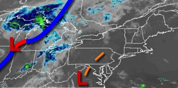
A cold front will move through the region tonight with isolated to widely scattered showers and thunderstorms. The thunderstorms will be capable of heavy downpours, frequent lightning, and wind gusts over 40 mph. Winds will be from the west at 5 to 15 mph. Temperatures will fall into the upper 60s to mid-70s for lows.
The cold front will linger off the coast tomorrow afternoon with scattered clouds and an isolated shower possible. Winds will be from the west at 5 to 10 mph. Temperatures tomorrow will rise into the upper 70s to mid-80s for highs.
An area of low pressure will move along the coast front with scattered showers on Thursday. Winds will be from the west at 5 to 15 mph. Temperatures on Thursday will range from the upper 50s to lower 60s for lows and mid-70s to lower 80s for highs.
High pressure will build into the region on Friday with clearing skies. Temperatures on Friday will range from the upper 50s to lower 60s for lows and upper 70s to mid-80s on the coast and mid to upper 80s elsewhere for highs.
High pressure will shift off the coast on Saturday with increasing humidity, areas of the morning fog, and scattered cloud cover in the afternoon. Temperatures on Saturday will range from the mid to upper 60s for lows and upper 70s to mid-80s on the coast and upper 80s to mid-90s elsewhere for highs.
A weak trough will linger over the region on Sunday with areas of fog in the morning and scattered clouds in the afternoon. Isolated thunderstorms will be a threat in the afternoon. Temperatures on Sunday will range from the lower to mid-70s for lows and mid-80s to lower 90s for highs.
A cold front will drop south from New England on Monday with isolated to widely scattered showers and thunderstorms. Temperatures on Monday will range from the upper 60s to lower 70s for lows and mid-80s to lower 90s for highs.
For details on your location, please visit the Local Seven Day Forecast!