Unsettled conditions are expected into this upcoming week with fog in the morning, thunderstorms in the afternoon, and plenty of humidity in between.
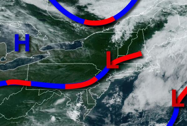
A stationary front will slowly drift south today with scattered to broken cloud cover and isolated showers and thunderstorms, especially over southern New Jersey. Winds will veer to the northwest at 4 to 8 mph. Temperatures will rise into the mid-80s to lower 90s along the coast and upper 80s to mid-90s elsewhere for highs this afternoon.
A cold front will drop south and then stall over the region tonight on through Tuesday with areas of fog in the morning along with scattered to broken clouds with widely scattered showers and thunderstorms. The thunderstorms will be capable of tropical downpours, frequent lightning, hail, and wind gusts over 40 mph. Winds will veer from the northwest to south at 5 to 10 mph. Temperatures tomorrow will range from the mid-60s to lower 70s
for lows and mid-80s to lower 90s along the coast and upper 80s to mid-90s elsewhere for highs. Temperatures on Tuesday will range from the mid-70s to lower 80s along the coast and mid-80s to lower 90s elsewhere for highs.
A stationary frontal boundary will linger over the region Wednesday on through Friday with fog in the morning along with scattered to broken cloud cover in the afternoon. Afternoon showers and thunderstorms will remain a risk with localized flash flooding a threat. Temperatures on Wednesday and Thursday will range from the mid-60s to lower 70s for lows and mid-80s to lower 90s for highs. Temperatures on Friday will range from the upper
60s to mid-70s for lows and mid-70s to lower 80s for highs.
An area of low pressure will produce periods of rain on Friday night through Saturday morning followed by lingering showers in the afternoon. Temperatures on Saturday will range from the upper 60s to mid-70s for lows and mid-70s to lower 80s for highs.
For details on your location, please visit the Local Seven Day Forecast!