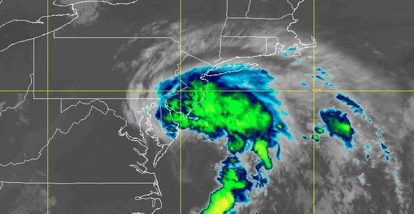
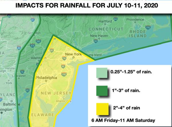
Tropical Storm Fay will lift northward along the New Jersey coast, into New York City, and eventually into the Hudson River Valley this evening. Waves of heavy rainfall will lift from south to north throughout the region, however, the heaviest rainfall will be found from the Delaware River Valley to the New Jersey coast and New York City metropolitan area. Winds will be from the east at 15 to 30 mph with gusts over 40 mph along the coast and
10 to 20 mph further inland with gusts over 30 mph. The strongest winds with Fay are expected to remain over the coastal waters. Flash flooding and poor visibility are expected with the heaviest rainfall. Temperatures will rise into the mid-70s to lower 80s for highs.
Fay will lift into the central Hudson River Valley tonight through tomorrow morning with lingering showers and thunderstorms capable of heavy tropical downpours. Winds will back from the northeast to the west at 10 to 20 mph. Temperatures will fall into the upper 60s to lower 70s for lows.
A cold front will follow tomorrow afternoon with scattered showers and thunderstorms a threat. The thunderstorms will be capable of brief heavy downpours, occasional lightning, and wind gusts over 40 mph. Winds will back to the west at 5 to 15 mph. Temperatures will rise into the upper 70s to mid-80s along the coast and upper 80s to lower 90s elsewhere for highs.
Another trough will follow on Sunday with scattered clouds and an isolated shower possible. Winds will be from the west at 5 to 15 mph. Temperatures on Sunday will range from the upper 60s to lower 70s for lows and mid-80s to lower 90s for highs.
A cold front will follow on Monday with scattered showers and thunderstorms expected. Temperatures on Monday will range from the upper 60s to mid-70s for lows and upper 70s to lower 80s for highs.
A series of frontal boundaries will linger around the region Tuesday on through Thursday with areas of fog in the morning followed by scattered to broken clouds in the afternoon. Isolated to widely scattered showers and thunderstorms will be a threat each afternoon. Temperatures through the period will range from the mid-60s to lower 70s for lows and mid-80s to lower 90s for highs.
For details on your location, please visit the Local Seven Day Forecast!