Comfortable weather conditions have settled over the region for today, but an active weather pattern returns by tomorrow.
Scattered clouds are expected through this evening. Winds will be from the west at 5 to 10 mph. Temperatures will rise into the upper 70s to lower 80s along the coast and mid to upper 80s elsewhere for highs.
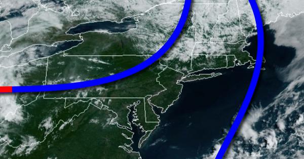
A cold front will drive through the region tomorrow with scattered showers and thunderstorms throughout the day. Winds will be from the southwest at 5 to 15 mph. Temperatures tomorrow will range from the upper 60s to lower 70s for lows and upper 70s to lower 80s for highs.
A weak trough will pass through the region on Tuesday with scattered
clouds and a few isolated showers. Winds will be from the northwest at 5 to 10 mph. Temperatures on Tuesday will range from the mid to upper 60s for lows and upper 70s to mid-80s for highs.
A warm front will lift through the region on Wednesday with scattered showers and thunderstorms. Temperatures on Wednesday will range from the upper 50s to mid-60s for lows and lower to mid-80s along the coast and mid to upper 80s elsewhere for highs.
A frontal boundary will linger over the region on Thursday with scattered clouds and isolated to widely scattered showers and thunderstorms. Temperatures on Thursday will range from the mid-60s for lows and upper 70s to lower 80s for highs.
A warm front will lift through the region on Friday with scattered showers and thunderstorms. Temperatures on Friday will range from the mid to upper 60s for lows and lower to mid-80s along the coast and mid-80s to lower 90s for highs.
A weak trough will linger over the region on Saturday with areas of fog in the morning followed by scattered clouds with isolated thunderstorms. Humid conditions are expected with temperatures ranging from the lower to mid-70s for lows and mid-80s to lower 90s for highs.
For details for your location, please visit the NY NJ PA Weather Local Seven Day Forecast!