No Signs Of Change In This Weather Pattern
|
The following is a preview of Premium Consulting Membership. For only $11 a month you too can get daily access on the latest weather information and news. Plus every Wednesday is a Live Video Chat at 7 PM Eastern discussing the latest events in
meteorology.
These weather conditions in place through Thursday might be one of the few breaks we'll get where we aren't keeping an eye on thunderstorms for the entire region. However, eastern Connecticut still couldn't dodge the bullet of showers and thunderstorms being a threat for the afternoon hours.
A few interesting points with the 12Z guidance this afternoon.
- The return of our active, humid, tropical weather pattern is slated for Friday with showers and thunderstorms in the morning followed by increasing humidity and more thunderstorms in the afternoon.
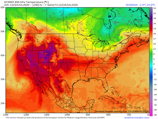
- While I expect a tropical air mass to return, I do not expect excessive heat like what will continue over the eastern Rockies, Plains, and Upper Mid West. Instead, our source region will continue to primarily from the Bahamas with secondary source regions from central Canada and the Canadian Maritimes.
- The return of dense fog is likely in the morning hours starting on Saturday morning.
- If you are in the Delaware River Valley, be prepared for increasing chances for severe thunderstorms and flash flooding. The pattern is developing such that cold fronts are going to either slow down over the region or just stall altogether.
- Any cool shots outside of this stretch will be brief, three days at most. However, I don't see strong support for prolonged heatwaves aside from southeastern and central Pennsylvania. I like a general temperature range of the upper 60s to mid-70s for lows and mid-80s to lower 90s for highs through the middle of August. Plenty of days of high temperatures around 88 or 89 degrees with dewpoints in the upper 60s to lower 70s, which will support a heat index in the
mid-90s many days.
- Finally, I am surprised to be writing this but through the next 15 days, the EPS and GEFS have no activity in the Tropical Atlantic. None. Now, we can't rule out some mischief along an old frontal boundary in the Gulf of Mexico or over the western Atlantic, but in terms of storms development over the central Atlantic or around Africa, the signal is as dead as could be. If the active hurricane season forecast is to verify, and it should, then the activity better
starts to increase in early August.
SUBSCRIBE TO PREMIUM CONSULTING MEMBERSHIP FOR MORE INFORMATION
|
|