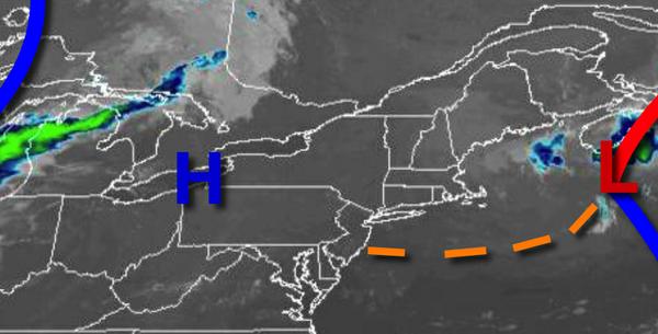
Sunny skies can be expected for many today as high pressure passes over the region. The tropical air mass returns by the end of the week with the threat of showers and thunderstorms.
High pressure will pass over the region today with clear skies to scattered cloud cover. An extremely isolated shower is possible over the Hudson Highlands. Winds will be from the north at 2 to 5 mph. Temperatures will rise into the upper 70s to mid-80s for highs today.
High pressure will exit tonight with scattered cloud cover and some fog towards morning. Winds will veer to the southeast at 5 to 15 mph. Temperatures will fall into the upper 50s to mid-60s for lows.
A warm front will approach tomorrow with increasing clouds and isolated thunderstorms in the afternoon. Winds will be from the southeast at 5 to 15 mph. Temperatures tomorrow will rise into the mid-70s to lower 80s for highs.
The warm front will move through on Friday with scattered showers and thunderstorms. Winds will veer from the southeast to south at 5 to 15 mph. Temperatures on Friday will range from the mid to upper 60s for lows and upper 70s to mid-80s for highs.
With the warm front well to the north of the region, a tropical air mass will be in place for the entire region Saturday on through Tuesday with locally dense fog in the morning and isolated to widely scattered thunderstorms in the afternoon and evening. Temperatures through the period will range from the lower to mid-70s for lows and lower to mid-80s along the coast and upper 80s to mid-90s elsewhere for highs.
For details on your location, please visit the Local Seven Day Forecast!