...EXCESSIVE HEAT WATCH REMAINS IN EFFECT FROM SUNDAY AFTERNOON
THROUGH TUESDAY AFTERNOON...

* WHAT...Dangerously hot conditions with heat index values up to
  111 possible.

* WHERE...Portions of southern New Jersey, northeast Maryland
  and central and southern Delaware.

* WHEN...From Sunday afternoon through Tuesday afternoon.

* IMPACTS...Extreme heat and humidity will significantly
  increase the potential for heat related illnesses,
  particularly for those working or participating in outdoor
  activities.

* ADDITIONAL DETAILS...The exact temperatures and heat index
  values will depend on the amount of cloud cover and coverage
  of thunderstorms each day.
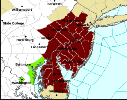
...EXCESSIVE HEAT WATCH REMAINS IN EFFECT FROM SUNDAY AFTERNOON
THROUGH TUESDAY AFTERNOON...

* WHAT...Dangerously hot conditions with heat index values up to
  110 possible.

* WHERE...In Pennsylvania, Delaware, Philadelphia, Eastern
  Montgomery, Lower Bucks and Eastern Chester. In New Jersey,
  Gloucester, Mercer, Northwestern Burlington and Camden. In
  Delaware, New Castle.

* WHEN...From Sunday afternoon through Tuesday afternoon.

* IMPACTS...Extreme heat and humidity will significantly
  increase the potential for heat related illnesses,
  particularly for those working or participating in outdoor
  activities.

* ADDITIONAL DETAILS...The exact temperatures and heat index
  values will depend on the amount of cloud cover and coverage
  of thunderstorms each day.
...EXCESSIVE HEAT WATCH REMAINS IN EFFECT FROM SUNDAY AFTERNOON
THROUGH TUESDAY AFTERNOON...

* WHAT...Dangerously hot conditions with heat index values up to
  108 possible.

* WHERE...Portions of central, northern, northwest and southern
  New Jersey and east central and southeast Pennsylvania.

* WHEN...From Sunday afternoon through Tuesday afternoon.

* IMPACTS...Extreme heat and humidity will significantly
  increase the potential for heat related illnesses,
  particularly for those working or participating in outdoor
  activities.

* ADDITIONAL DETAILS...The exact temperatures and heat index
  values will depend on the amount of cloud cover and coverage
  of thunderstorms each day.