Periods of rain this morning is just the beginning of an active and very wet weather pattern.
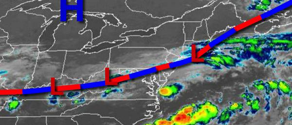
A stationary front with waves of low pressure will slowly sink south through this afternoon with waves of showers and thunderstorms this morning giving way to clearing skies by the evening. Winds will veer to the northeast at 5 to 10 mph. Temperatures will rise into the mid-70s to lower 80s for highs this afternoon.
High pressure will build into the region tonight through tomorrow with clear skies to scattered cloud cover. Winds will veer from the northwest to southeast at 5 to 10 mph through the period. Temperatures tomorrow will range from the mid to upper 60s for lows and mid-80s to lower 90s throughout the region.
A warm front will approach on Sunday with increasing clouds and scattered showers in the afternoon and evening hours. Winds will veer to the southwest at 5 to 10 mph. Temperatures on Sunday will range from the upper 60s to mid-70s for lows and mid-80s to lower 90s for highs.
The warm front will stall over the region on Monday with areas of fog in the morning followed by scattered clouds and isolated thunderstorms in the afternoon. Temperatures on Monday will range from the upper 60s to lower 70s for lows and mid to upper 80s for highs.
By Monday night, Hurricane Isaias will be approaching the North Carolina coast and turning north. The exact impacts and track of this storm are still uncertain, however, this storm is likely to have some impacts on the region Monday night on through Wednesday morning with periods of heavy rain, strong winds over 40 mph, flash flooding, and coastal flooding. Conditions are expected to improve rapidly with clearing skies on Wednesday afternoon.
Temperatures on Tuesday will range from the upper 60s for lows and lower to mid-70s for highs. Temperatures on Wednesday will range from the upper 60s for lows and lower to mid-80s for highs.
High pressure will be in control on Thursday with clear skies to scattered cloud cover. Temperatures on Thursday will range from the upper 50s to mid-60s for lows and mid-70s to lower 80s for highs.
For details on your location, please visit the Local Seven Day Forecast!