A warm front moving through this morning kicks off a very wet weather pattern fo the region through the start of this upcoming week.
A warm front will continue to lift through the region with scattered showers and strong to severe thunderstorms through this afternoon. Winds will be from the southwest at 5 to 15 mph. Humid conditions can be expected with temperatures rising into the lower to mid-80s along the coast and upper 80s to lower 90s elsewhere for highs.
A weak trough will linger over the region as the warm front lifts well to the north tonight on through tomorrow morning with areas of fog, low clouds, and isolated showers. Winds will be from the southwest at 5 to 15 mph. Temperatures will fall into the lower to mid-70s for lows.
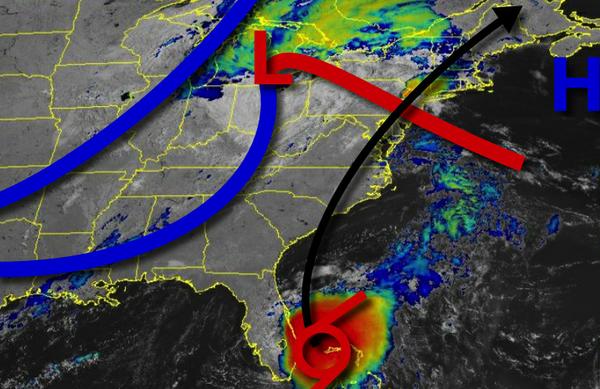
Moisture from Tropical Storm Isaias will begin to move into the region tomorrow afternoon and evening with scattered showers and thunderstorms capable of tropical downpours will begin to increase in coverage. Winds will be from the southwest at 5 to 15 mph. Temperatures will rise into the mid-80s to lower 90s for highs.
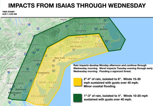
On Tuesday, the remnants of Isaias will approach the region with widespread rainfall and embedded thunderstorms capable of intense tropical downpours and wind gusts over 40 mph. The heaviest rainfall can be expected Tuesday evening through early Wednesday morning as the core of the remnant low of Isaias moves through the Delaware River Valley towards central Connecticut. Winds will back from the south to the northwest at 15 to 30 mph with
gusts over 40 mph along the coast and 10 to 20 mph with gusts over 30 mph over the interior. Flash flooding will be a high threat along with minor wind damage and minor coastal flooding. Temperatures won't move much with lows in the lower to mid-70s and highs in the mid to upper 70s.
A strong cold front will follow on Wednesday morning with scattered showers and thunderstorms. Skies will clear in the afternoon and evening with falling humidity expected. Temperatures will range from the upper 60s to mid-70s for lows and lower to mid-80s for highs.
High pressure will produce clear skies to scattered cloud cover on Thursday. Temperatures on Thursday will range from the mid-60s to lower 70s for lows and lower to mid-80s for highs.
A wave of low pressure off the coast will produce scattered to broken clouds and isolated showers on Friday and Saturday. Temperatures on Friday and Saturday will range from the upper 60s to lower 70s for lows and upper 70s to lower 80s for highs.
For details on your location, please visit the Local Seven Day Forecast!