...FLASH FLOOD WATCH IN EFFECT FROM MONDAY EVENING THROUGH
TUESDAY EVENING...
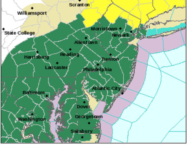
The National Weather Service in Mount Holly has issued a
* Flash Flood Watch for portions of Delaware, northeast
Maryland, New Jersey, and Pennsylvania, including the
following areas, in Delaware, Delaware Beaches, Inland Sussex,
Kent, and New Castle. In northeast Maryland, Caroline, Cecil,
Kent MD, Queen Annes, and Talbot. In New Jersey, Atlantic,
Atlantic Coastal Cape May, Camden, Cape May, Coastal Atlantic,
Coastal Ocean, Cumberland, Eastern Monmouth, Gloucester,
Hunterdon, Mercer, Middlesex, Morris, Northwestern Burlington,
Ocean, Salem, Somerset, Southeastern Burlington, Sussex,
Warren, and Western Monmouth. In Pennsylvania, Berks, Carbon,
Delaware, Eastern Chester, Eastern Montgomery, Lehigh, Lower
Bucks, Monroe, Northampton, Philadelphia, Upper Bucks, Western
Chester, and Western Montgomery.
* From Monday evening through Tuesday evening
* Heavy rain associated with Tropical Storm Isaias is expected to
start as early as late Monday evening and will continue through
the day Tuesday. Widespread amounts of 3 to 5 inches are likely
with locally higher totals possible.
...FLASH FLOOD WATCH IN EFFECT FROM MONDAY EVENING THROUGH
TUESDAY EVENING...

The National Weather Service in State College has issued a

* Flash Flood Watch for a portion of central Pennsylvania,
  including the following areas, Adams, Cumberland, Dauphin,
  Franklin, Fulton, Lancaster, Lebanon, Perry, Schuylkill, and
  York.

* From Monday evening through Tuesday evening

* Heavy rain associated with Tropical Storm Isaias is expected to
  start as early as Monday evening and will continue through
  Tuesday. Rainfall amounts of 2 to 4 inches are most likely with
  locally higher amounts possible.

* This amount of rain may result in significant flash flooding
  especially in urban areas and on small streams and creeks.
...FLASH FLOOD WATCH IN EFFECT FROM TUESDAY MORNING THROUGH LATE
TUESDAY NIGHT...

The National Weather Service in Upton has issued a

* Flash Flood Watch for portions of northeast New Jersey and
  southeast New York, including the following areas, in
  northeast New Jersey, Eastern Bergen, Eastern Essex, Eastern
  Passaic, Eastern Union, Hudson, Western Bergen, Western Essex,
  Western Passaic, and Western Union. In southeast New York,
  Bronx, Kings (Brooklyn), New York (Manhattan), Northern
  Queens, Northern Westchester, Orange, Putnam, Richmond (Staten
  Island), Rockland, Southern Queens, and Southern Westchester.

* From Tuesday morning through late Tuesday night

* Rain showers with embedded thunderstorms out ahead and with
  Tropical Storm Isaias will move into the region Tuesday into
  Tuesday night. A total of 2 to 4 inches of rain will be possible
  with locally higher amounts between 4 and 6 inches. Torrential
  downpours with multiple rounds of heavy showers will allow for
  excessive runoff and therefore would cause flash flooding in low
  lying, urban and poor drainage areas. Some smaller streams and
  rivers may exceed their banks.